
On a hike around Mississippi Palisades State Park, we walked around the bend and encountered this old water tower rising up from a field filled with blossoming milkweed. No doubt a haven for Monarch butterflies flying around the Mississippi River.

On a hike around Mississippi Palisades State Park, we walked around the bend and encountered this old water tower rising up from a field filled with blossoming milkweed. No doubt a haven for Monarch butterflies flying around the Mississippi River.

Children and adults alike cool off in the Whirlpool Compass Fountain in St. Joseph, Michigan. Just steps from Silver Beach, Lake Michigan, and the downtown shopping district, the fountain provided some much needed relief from the 90 plus degree sun.
Every few minutes, the top nozzles blast water overhead. In between sprays, dozens of small fountains of water come up from the ground providing lots of opportunities to cool off.

Following some afternoon storms, the sun made a brief appearance over the lake. The trees still dripping with moisture, glistened as the fog rolled in the distance.

In 1860 John Dye lived on this 120 acre farm along with his wife , four children and six slaves. They raised corn, wheat, and hay on the nearby rolling hills. In 1862 Confederate General Simon Bolivar Buckner commandeered this house for his headquarters during the historic Battle of Perryville, which took place about a mile away. The house was used as a field hospital after the battle. Blood stains can still be seen on the floors of the upstairs rooms.
General Buckner later became Governor of the Commonwealth of Kentucky, and was the “Gold Democrat’s” vice presidential nominee in 1896. He died near Munfordville, Kentucky in 1914.


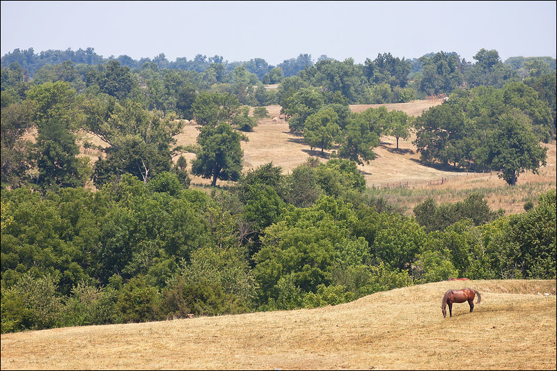
In the midst of a string of 100 plug degree days, the rolling countryside of Hardin County, Kentucky showed signs of drought. Overnight, fog would fill the fields with a trace of moisture, only to evaporate before quenching the parched ground.
This field seemed relatively healthy, possibly due to it's low-lying location. Many other fields were brown, and several creeks were completely dry.


On the way to an early morning hike to the top of a secluded, not-so-well-visited knob (prominent rounded hill), I was presented with some beautiful scenery along a small country road.
Daytime temperatures were well into the 100s, and at 6:30 am, the countryside was filled with fog - the only source of moisture in this region for weeks.
Now peaceful, these hills were witness to an important event in Kentucky History. The Battle of Perryville was fought here on October 8, 1862, marking the end of Confederate General Braxton Bragg's famous "Kentucky Invasion." It was the largest battle fought in Kentucky during the Civil War.
1426 men were killed, 5552 wounded. It's considered to be one of the bloodiest battles of the war.

A dragonfly I found struggling to get out of an abandoned spiderweb. I removed him to let him fly free, but instead, he stayed perched on my finger for about ten minutes - resting after the ordeal.

One of the first large scale uses of concrete construction in the country, the Hennepin Canal linked the Illinois River with the Mississippi River. Along the 104.5 mile waterway, locks were constructed of concrete, unlike the Illinois and Michigan Canal's limestone block locks.
Lift bridges were located in a few places to provide a place for wheeled vehicles to cross the canal. This lift bridge on Lock 21 near Wyanet, Illinois still stands, and traffic is allowed to drive over.
The location of the Hennepin Canal is much more rural than most of the I and M Canal, so a walk along the towpath is very peaceful and scenic.

The wait and stalking are over. The Prickly Pear cacti are finally in bloom at the Indiana Dunes National Lakeshore.
Not commonly seen around Chicago or Northwest Indiana - yet not rare at all - the Prickly Pear cactus is in full bloom. Flowering in late June, the cactus blossoms last only one day. The Indiana Dunes National Lakeshore's West Beach and Inland Marsh trails have scores of these growing in the sandy soil. I've also run into them (literally) near the beach in Cowles Bog and along the I and M Canal in LaSalle, Illinois.

The View from atop the cliffs along the Mississippi River is well worth the climb up. Not realizing one could drive up to the top, park the car and walk 100 feet to an overlook, Ken and I climbed up a steep, winding trail from the road below. Once at the top, we were greeted by others who drove - lesson learned, but I enjoyed the climb!
Mississippi Palisades State Park has quite a few short trails, leading to some nice views of the river valley, and some natural rock formations. It appears rock climbing is allowed - I discovered several anchor points drilled into the rock face on the top of Indian Head, a rock formation resembling a human head.
Looking out over the river and Buffalo Lake, the trees of Iowa can be seen in the distance.

Today, a rare event took place - the passing of the planet Venus between the Earth and the Sun, giving us a unique view of our neighbor silhouetted against the blazing sun. To safely view the transit, I set up a telescope, aimed it at the sun (without looking through it of course), then placed a white card about a foot away from the eyepiece. This creates a projection of the sun on the white card, and saves your eyeballs from melting!
After the sun got too low to view projections, we ventured off to the countryside to watch the sun set. With a 300mm lens, I was barely able to capture the planet against the sun, but if you look close, it's there. Venus is about 30 million miles away from us, and the sun is over 80 million miles away, that makes the distance between the sun and Venus around 50 million miles. At that distance, the Sun dwarfs the planet - imagine how small it would be right next to the Sun.
Venus will not transit across the Sun again until 2115, so this is the last time any of us will probably see this. It's an important learning event for scientists as well. A planet's atmosphere can be see when it is against a star, and, the distance from the star can be determined during the transit.
At least we didn't just read about this event after the fact.

Another species that seems out of place at the Indiana Dunes National Lakeshore, is the Prickly Pear Cactus. They're quite plentiful in the grassy areas of West Beach and the Inland Marsh, yet they're not found too often anywhere this far north. I have seen some in the sandy, areas of LaSalle, IL as well.
They almost totally shrivel up in the winter, and lose their spines. Right now, the spines are developing, seen here emerging from the areoles; I'm pretty sure they have tiny spines called glochids which really cause skin irritation. New pads and buds for their flowers are forming as well. Hope to capture them flowering soon.

Bet you won't believe it, but this lizard was photographed at the Indiana Dunes National Lakeshore.
Common to the southern United States, the Six Lined Racerunner (Cnemidophorus Sexlineatus Viridis) has a small population around southern Lake Michigan. Miles of sand dunes must have kept conditions just right to support these creatures this far north. They're not too rare at the park - I spot them almost every visit in the summer.
Lizards, hot sandy beaches, prickly pear cactus, carnivorous plants....... all at the Indiana Dunes National Lakeshore!
Surprised?

These two Cabbage White butterflies were enjoying the recent 90 degree temperatures on the dunes of Central Beach, at the Indiana Dunes National Lakeshore.
Cabbage Whites are very common, and easy to tell apart. In addition to the marks on the tips of the wings, females have two black spots on their wings, while males only have one.
Eggs are laid on the underside of the leaves of plants in the mustard family, but they have a particular love for cabbage and broccoli plants.


