Capricious

Capricious

From sun to rain, and everything in between - that's what we experienced while walking the beach at St. Joseph, Michigan. One moment the sun was shining, the next it was raining.  It didn't force us to alter our plans, we still enjoyed the beach.  In fact, the changing weather made for some great interest in the sky.

Once a few raindrops fell, almost all the beachgoers fled, and we had the beach pretty much to ourselves. Rain showers only lasted a few minutes at a time, with plenty of rainless periods in between.

It was odd, however, to see our footprints in the wet sand - they were completely dry. quite the opposite of walking on pavement, the wet sand stuck to our feet, and revealed dry sand underneath.

Dam Ruins

Dam Ruins The ruins of a small dam located in Dellwood Park, in the town of Lockport, Illinois. The park was built in 1905 by the Chicago and Joliet Electric Railway Company to gain ridership on the small line. Two dams were built on the small creek that runs through the small limestone canyon to create deeper water for recreation. A boat house, dancing pavilion, and other amenities were constructed, making Dellwood Park one of the most picturesque parks in the area. The railroad was used to transport visitors to and from the park on weekends - thousands picnicked on the grounds, and rowed boats in the man-made lagoons each weekend. The dams are still visible today, but no longer hold water.

Sunset Mirage

Sunset Mirage


A boat heads for home as the sun sets over Lake Michigan. On the last weekend of Summer, rain showers interrupted much of the day, yet as if on queue, the sky cleared for sunset. As we watched the sun dip below the horizon for the last time this summer, I noticed the usual bands of red, yellow, and white appear on the photos I captured. Adusting the shutter speed to bring out the intense reds in the clouds, only brought out more of the bands in the sun. Just as the moon appears larger and more colorful when it's lower in the sky, the sun also appears to change at sunset. When the moon or sun is low in the sky, the light emitted from them must travel through more of the earth's atmosphere. The atmosphere is different temperatures at different levels, so the light is distorted a bit at each level, creating a mirage that changes the shape and color of the sun as it sets. That's why the solar disk is flattened and has different bands of color.

Summer's Last Breath

Summer's Last
Following a day of showers, the sun illuminated the few remaining clouds left in the sky as evening approached. Almost giving up on a walk on the beach, we turned back after the last raindrops fell, and arrived a few minutes before sunset.

The sun did make an appearance, and we were able to watch the full solar disk disappear below Lake Michigan for the last time this summer. We'll continue to visit the beach throughout the Fall and Winter, but summer sunsets hold a special place in our souls.

This was like watching a good friend drive away after a long summer vacation. We'll stay in touch, but things won't be the same until we meet again next summer.

Heavy Surf

Surf

Standing guard in heavy surf, the Michigan City, Indiana East Pierhead lighthouse acts as a beacon for the sailboats and kitesurfers who dared to enter the water on such a windy day.

Known as an inland sea, Lake Michigan covers over 22,400 square miles -large enough for ocean going vessels, and considered just as dangerous as the ocean when it comes to waves. On this day, the waves were only about 4 to 7 feet high, but their frequency seems greater than that of most oceans. Still, sailboats and kite surfers were not deterred; with a lot of skill, and a little luck, all returned to shore safely.

Clouds and Whitecaps

Clouds and Whitecaps

Still warm enough to enjoy the outdoors, the boys climb on a log that washed up on the beach.  The waves were strong enough to move the log as they stood on it, making for some fun "surfing." Lake Michigan water temperatures were probably in the low 60s or high 50s, so getting splashed by the waves wasn't comfortable, but it was exciting.

Avoiding the Wave

It seems right after Labor Day, the temperatures drop enough for it to feel like Fall, and the winds begin to churn up the lake.  When the winds come from the northwest, the clouds seem to hang right over the lake, like a cotton ceiling; almost endless.

Touching the Dunes

Touching the Dunes

High winds kicked up Lake Michigan, and drove the surf far onto the beach - up to the sand dunes. Visitors on this cool weekend were forced to walk in the waves, as the beach all but disappeared due to the high water.

Waves crashed into the dunes, causing some erosion and small slides, as the sand washed into Lake Michigan. Walking along the beach was challenging; we couldn't walk on the dunes because they're protected - people's footprints will erode them.  Seems Lake Michigan was doing a pretty good job of eroding the dunes without the help of visitor's feet.

This natural process happens time and time again, regardless if man is present. He is a witness.

Patterns

Patterns

Plenty of duckweed, fallen trees, stumps, water birds, and shadows - all the makings of an interesting swamp. This week, we decided to take a short hike from Central Beach to the swamp, to see what was new in this wetland.

Most visitors to the Indiana Dunes National Lakeshore, generally stop at the beach; they're not aware of the other interesting places to see in the park.  Woods, forests, grasslands, bogs, farms, are all part of the park, and I think just as interesting and beautiful as the lakeshore.

As we drive to different places in the park, we pass this swamp, and each time I notice the changes that occurred since our last visit.  Following a storm, there are new fallen trees; during a dry period, the water often dries up. Most changes, however, are so subtle, that visitors won't take notice of them as they head to the beach. The wildlife changes as well.  Frogs are among the first creatures to make an appearance in the Spring, followed by sightings of turtles, blackbirds, then waterbirds migrating from the south. Snakes and lizards can be seen in early summer, along with mosquitoes and biting flies.

As the Summer winds down, we'll experience the more obvious changes of Fall. As the leaves turn color and drop, many of the animals will hibernate or head south before the lush green turns to fluffy white.

Beach Goers

Beach Goers It seems every year, right after Labor Day, everything takes on a different look. The clouds and sky seem more vivid, the sun all of a sudden moves to a drastically different angle, and the days seem cooler and windy. I'm sure it has a lot to do with Fall approaching, and perhaps Labor Day simply provides a point of reference where we begin to notice these changes that have taken place for weeks prior. With early morning temperatures in the low 60's, and winds howling across Lake Michigan, we still set out in shorts and short sleeves to explore the beaches of the Indiana Dunes National Lakeshore. Nothing unusual there - we visit in January too! After a walk along the shore, the sun warmed things up, and we took to the water. The winds were whipping up the lake, creating some high waves, and pushing the water onto the beach, up to the dunes in some places. We witnessed the collapse of small portions of the dunes as the waves hit - something natural, and not due to people walking on them as the park service might seem to indicate with the closing of the paths on most every dune in Indiana. Due to man? Maybe; the construction of the Michigan City pier generations ago has starved these beaches of sand. Many people have closed up their summer cabins, taken their boats out of the water, and no longer think about visiting the beach, but we're still in summer mode, enjoying the sun, sand, and surf.

Exploring the Marsh

Exploring the MarshThere are plenty of small streams the cut through the dunes and empty into Lake Michigan, and we manage to find most of them! This particular one formed a small marsh just before it entered Lake Michigan, making it a fun area for the boys to explore. Probably due to the beachgoers, not many creatures were hanging around the marsh on this morning, but we did come across plenty of dragonflies. Soon, the weather will begin to turn cold, and crossing these small streams will not be as easy - at least, not as comfortable - as it is in the summer months.

Sunset Plunge

Sunset PlungeTaking advantage of the last weekend before school, the boys swam in the lake until dark. Nothing unusual for them - they tend to swim all day anyway, but this week seemed different. The weather turned rainy during dinner, but cooperated and stopped in time for them to enjoy the lake for a few more hours. Sunset itself wasn't too spectacular, but as the sun dropped below the horizon, the clouds broke up and displayed some beautiful golden colors against the dark blue sky. I've found this to be the case numerous times when disappointed by the sunset, stick around for 30 minutes, sometimes the sky is more amazing after sunset. With any luck, we'll repeat this scene a few times during the next few weeks.

Just Past the Golden Hour

Just Past the Golden Hour


It's said that one of the best times for photography is the "golden hour," an hour just before sunset. I've found this to be true, but I've also found that the minutes just after sunset can create striking images as well. Using the golden hour, generally the sun is behind the camera, illuminating the subject in golden light. This image was shot into the light created by a colorful sunset after a storm moved through the area. No color enhancing in this image, they sky was on fire. The fun certainly doesn't end at sunset. The boys enjoyed a summer day swimming in the lake until a storm rolled in at dinner time. After a meal and dessert the rain ended, allowing them to get back in the water until dark. School is in session again, but summer isn't over yet.

Wetland from the Dune Ridge

Wetland Below the Dune Ridge
An easy hike up from the trail head on a normal day, this turned into a workout in the heat and humidity. No complaints here.

3/4 of the way to the ridge, we were greeted by several Cicada Killer wasps - huge wasps that hunt cicadas in mid flight, then return with them to their burrows to feed their larvae. They're quite intimidating, but if you realize the ones that seem to fly at you are male and have no stinger, you allow them to fly toward you. The larger female can sting, but is timid, and usually won't bother.  They're about the size of an adult's thumb.

Eastern Cicada Killer
After several minutes watching the wasps battle for territory, we headed up to the ridge of the dune for a great view of the wetlands below. In summer, the view is mostly shielded by green leaves, but in winter when the leaves are gone, you have a wider view of the area.

Also found along this trail are six lined racerunner lizards - in fact, at times you can see half a dozen in a few yards.  These lizards are found in many locations within the Indiana Dunes National Lakeshore.
Six Lined Racerunner

Peaceful Now

Peaceful

The battlefield where Confederate General Bragg completed his "Kentucky Invasion" is now quiet. On this site in October 8, 1862,  1,355 men were killed, and over 5,000 were injured fighting for control over this piece of land.

It's difficult to walk through this rolling countryside without sensing the battle that took place here. The thousands killed and injured, the artillary pounding the front line, the chaos, and the incredible noise.

Peaceful now.

Shady Acres

Shady Acres
On our visit to Munfordville, I stopped to walk around a rustic barn on the Anthony Woodson Farm. Like hundreds of other barns I've seen in the countryside, this one is still structurally sound, but the weathered siding hints at its age.

The short time on this farm made me think of all the barns once utilized in this part of Kentucky - especially tobacco barns. I remember just 25 or 30 years ago, seeing field after field of tobacco on my drive to Mammoth Cave, each had a rustic tobacco barn on the property.  Now, I struggle to find a single tobacco field in this area.

The barns in the midsection of the country are slowly fading away, and crumbling - no longer needed, or replaced by uninteresting steel-sided boxes.

Battlefield to Hay Field, Munfordsville, Kentucky

Munfordville Battlefield
Our interest in the American Civil War brings us to plenty of historic places, and one of the lesser known favorites of ours is Munfordville, Kentucky. A city of 1,600 people, Munfordville is the county seat of Hart County.
View from Fort Craig
A stop along the Louisville and Nashville Railroad, and the site of railroad bridge crossing the Green River, Munfordville was an important route for Union supplies heading south.  Confederate General Bragg's army arrived in Munfordville on September 14th, 1862, and demanded surrender of the Union forces dug in at Fort Craig, a small fort about 1000 yards from the railroad bridge.
Fort Craig


A battle ensued for control of the bridge over the Green River.  Union forces were well positioned, but did not anticipate their exposure on the opposite bank of the Green River, and the Confederates took advantage.

Even though it was a small battle, the battle flag of the 67th Indiana Infantry had 146 bullet holes in it following the fighting. After three days of fighting, the casualties totaled 4,862 - Union 4,148; Confederate 714. On September 17th, Col. John Wilder surrendered to avoid unnecessary civilian casualties. This important transportation point was now under Confederate control, hampering the movement of Union supplies.
Crossing the bridge
Trains still cross the Green River on the same bridge today, and the battlefield is an historic preserve open to the public.  The site of Fort Craig can be seen next to the battlefield, now only the earthen mounds are present, as the wood from the fort was used as firewood after the war.

Adjacent to the fort is the Green River Church Cemetery, a small graveyard overlooking the rolling hills, Green River, and railroad bridge.
Green River Cemetery

Just across the River in Munfordville proper, is the Green River Park and Arboretum. This quiet city park includes a small loop hiking trail, boat ramp, playground, canoe rental, and views of the Green River. It's also the site of the Big Buffalo Crossing, memorialized by a life size buffalo statue which children enjoy. It provides a green backdrop to a relaxing walk under the 31W bridge.
The Bank of the Green River

The trailhead for the 4.5 mile Jenny Wilson Byrd Memorial Trail is at the eastern end of the park.
Green River Trail

This trail follows the bank of the Green River, and is the trail we'll explore next time we visit the area.  Just a few feet from the trailhead is the old pump tower. Built in 1915, this tower elevated river water to town level, providing water for Munfordville. It stands today as a piece of local history.
Pump tower

Downtown Munfordville offers small town charm, including eating establishments, and shops along a strip of historic storefronts.  Of particular interest is the old Coca Cola sign, painted on the side of a business.  Most likely a repaint, but really makes you think of times gone by.
Coca Cola Sign

Kentucky Knob

View from the Knob

As a child, driving down I-65, on our trip south to Florida, I would gaze out the window at the hilly landscape of north central Kentucky. These were the first "mountains" we encountered each year - pretty exciting when you spent the last seven hours looking at the flat lands of Indiana. I often wondered what it was like on top of those hills.  Finally, as an adult, I found a trail that winds through the forested ridges of these hills - Knobs State Forest and Wildlife Management Area.

Orange Trail
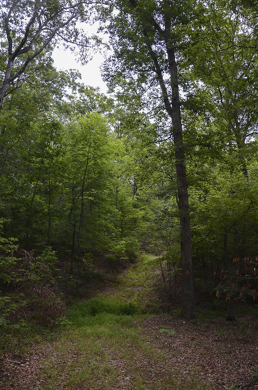
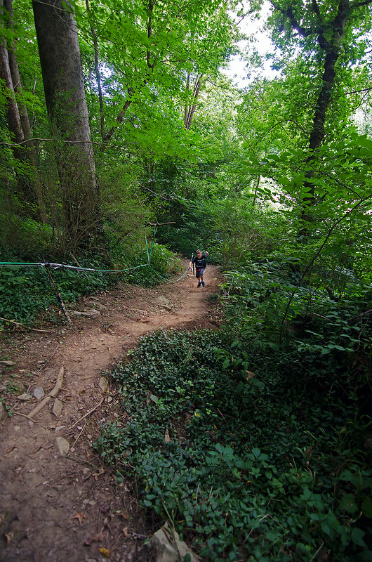
Set aside in 2006, this 1500 acre reserve in Bullitt County, Kentucky gives visitors a chance to see these wooded knobs from ground to ridge. Four interconnecting trails totalling a bit over 6.5 miles meander up and down the knobs, allowing visitors to view most of the forest.  The trails seem to be former logging roads, about 8 feet wide and packed down where tires once rolled.  They are, at times, covered in knee-high groundcover, but well defined for the most part, with the exception of a few places that had us guessing the correct route.

The difficulty was mostly moderate as the trails headed up and down the landscape, but strenuous at times depending upon the rise in elevation - especially reaching the top of the knobs at the end of the 2.5 mile long trail.  

Our day began at 4 am, when Chris and I headed to the car while everyone else slept. We drove the easy 25 miles to the tiny gravel parking lot about 100 feet off of Crooked Creek Road. Unsure at first, I passed it up, but later found that we had to drive through Crooked Creek to get to the parking lot.  On this day the creek was dry, allowing us easy access to the parking lot.

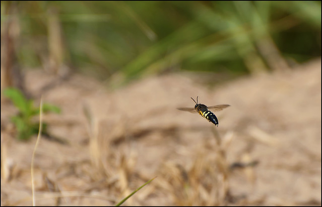
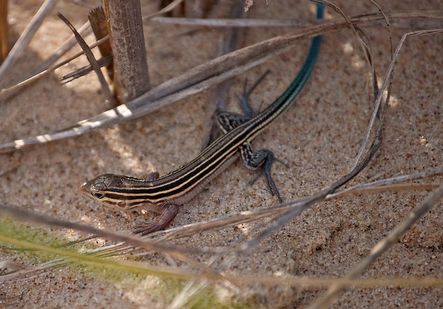
Ready for our battle with insects, we brought along plenty of deet, long sleeves and long pants, and a roll of black duct tape. Not wanting to deal with ticks, I taped the bottoms of our pants to our boots to prevent ticks from crawling up onto our legs. (a much better option than tucking the pants into socks as most hiking websites suggest)  I also taped my pockets to prevent my car keys from slipping out during the hike. The tape worked very well in both cases, especially with the ticks, we each had only one tick on the outside of our jeans on the entire 6 mile hike.  Spiders, however, were plentiful - very plentiful, and attached themselves to my shirt and head dozens of times during the hike, as I broke through their large webs.

Hiking up the Knob

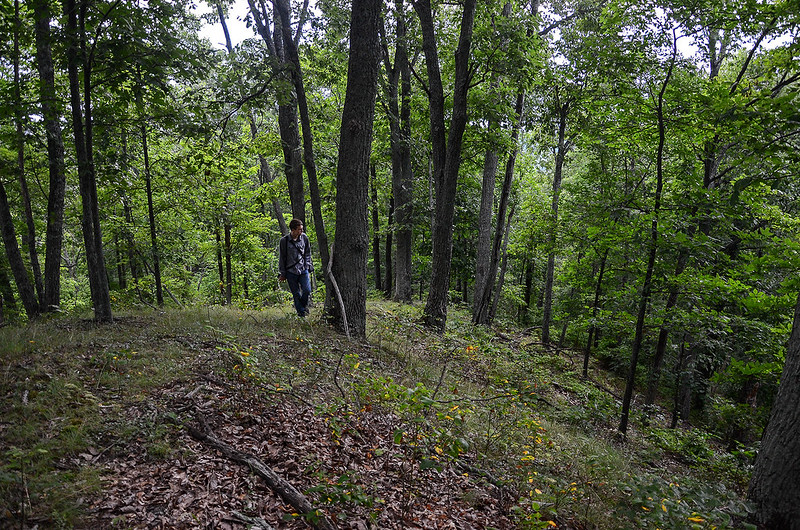
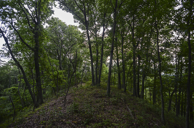
As we set out, the sun had not risen, yet a bit of light was evident in the sky, allowing us to see the trails well enough in the thick woods. One only two occasions we questioned the route.  Generally well marked with colored diamond labels on select trees, the trails intersected at times, making us stop and search for the correct trail. And what we thought was the end of the orange trail, was only a turn up to the top of the knob - a steep ascent with no apparent trail markings or flattened foliage.  Our best guess turned out correct as we spotted a few orange diamonds on trees ahead of us.

The path up the Knob

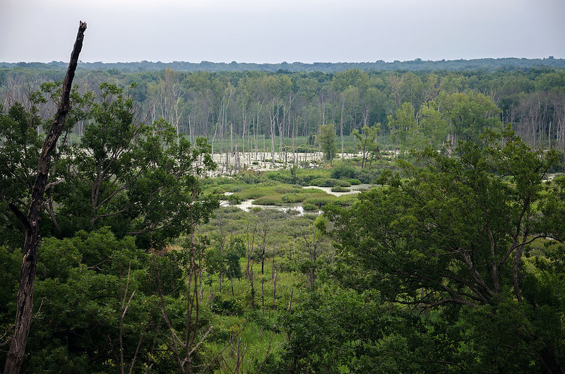
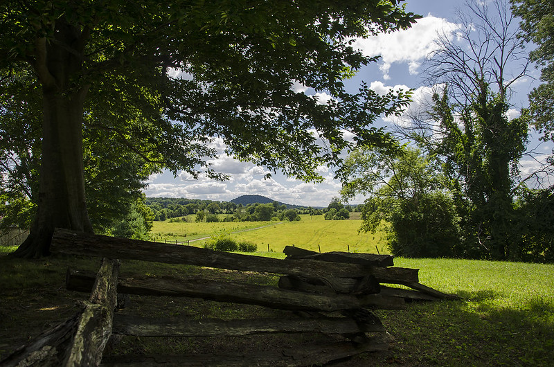
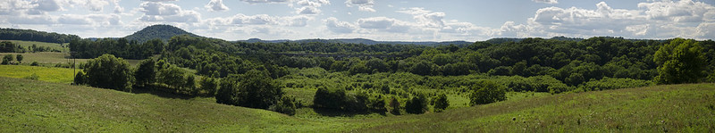
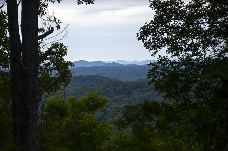
Well worth the strenuous climb to the top of the knob (at 941 feet), we were rewarded with an interesting landscape as well as a few small spots offering excellent views of the rolling countryside. I can only imagine how the view is during the winter and early spring before the leaves fill the trees.

Narrow Ridge

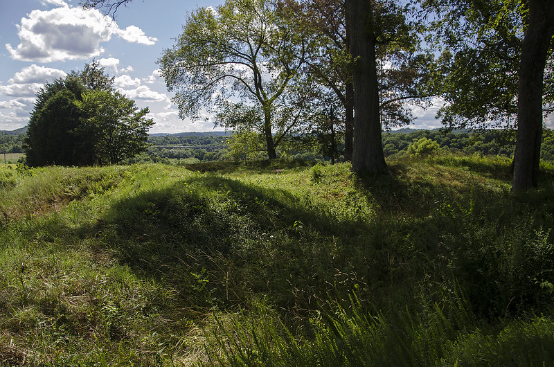
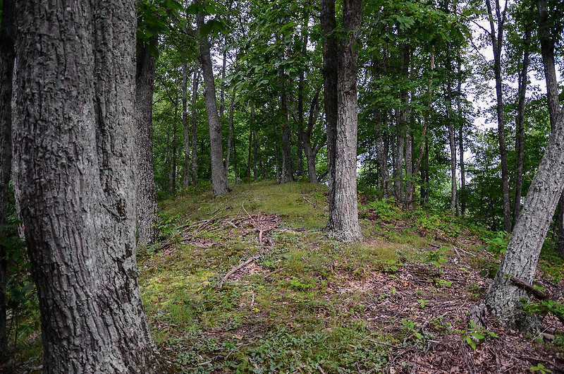
Disappointed we weren't able to stay longer, we soaked in the views, and the unusual silence of this place. What amazed me is the quiet we experienced with I-65 only a mile or two away; we heard absolutely nothing.  Of particular interest was the narrow ridge of the knob.  The trees seemed to lean away from the top, giving us the feeling we were walking on top of the forest.

For a few seconds, we lost the way down to the trail from the ridge.  This portion of the trail had no matted down or worn down areas, so it blended in perfectly with the rest of the forest floor.  We knew the only view we had was on our left as we climbed, so we proceeded to slide down the hillside with the view to our right.  Sure enough, we spotted the orange diamond on a tree behind us, and a few minutes later, we connected back at the well defined portion of the trail. Our walk back was at a faster rate, but a bit strenuous in spots, probably due to the climb previous. 

It was certainly worth waking up early to walk through this part of Kentucky, a part that most visitors don't see, and a part that I finally experienced after years of wonder. Back to the hotel to celebrate with an ice cold Ale 8 1, a soda manufactured in Kentucky since 1926.


Rolling Through Lemont

Rolling Through Lemont
A Burlington Northern and Santa Fe freight train rolls over the Sanitary and Ship Canal on the Lemont Railroad Bridge.  Constructed in 1898 by the Keystone Bridge Company of Pittsburgh, the steel swing bridge has a span of 375 feet, and is frequently used by the railroad.  During our 30 minute walk, three trains passed over this bridge.

lemont

In Lemont for the weekly Lemont Ledgends cruise night, we often explore the area after viewing the custom and vintage cars parked up and down the downtown streets. This time, we decided to to hike over the Lemont Ave bridge to view the I and M Canal, Sanitary and Ship Canal and the DesPlains River - all within a block or so of each other, and the downtown area.  Used heavily for industry, the Sanitary and Ship Canal is filled with tugboats and barges, but offers few places for viewing other than bridges.

sitting

As we approached the top of the bridge, over the canals, we noticed a small area on the bank of the canal with some sort of a stone memorial, and a few teenagers sitting near it. Figuring it must be a small acess point, we made our way back downtown to find it.

memorial

In short order, we discovered a narrow path that led from a side street to the bank of the canal.  The memorial we saw from the bridge, honored mariners of the Illinois Marine Towing company, a local frieght company. Perhaps this small landing is a place for the deckhands to stop for a break, or a walk to town.

Either way, it offered a view of the canal traffic, as well as a safe place to watch traffic on the railroad bridge.

Stately Dilapidation

Stately Dilapidation

On our journey down old Route 66, south of Bloomington Normal, we found ourselves wandering off the route after missing an unmarked turn.  Instead of doubling back a mile or so, we took a detour down a small road that eventually connected to Route 66.
This stately farmhouse, seemingly unoccupied for many years, has seen better days, yet the grounds were manicured beautifully. The tall trees framed the home when viewed from the road, inviting us to take a closer look.

Taking it Slow

Taking it Slow

On our drive down the old Route 66, we came across the tiny town of Funk's Grove, Illinois.  We didn't see a downtown, a business district, or anything actually, yet as we followed a small road that intersected Route 66, we came across a very well manicured and maintained small church, cemetery and nature preserve.  The Sugar Grove Nature Center is free, and open year-round from dawn to dusk.  There are several well marked trails that wind through Illinois' largest intact prairie grove, a small nature center, barn, firepit, and friendly staff.

One trail leads hikers about a mile to the Funk's Grove Church and Cemetery, and the Chapel in the Trees, an outdoor church with huge logs acting as pews and lecterns.

Hiking through the dense, damp woods, we came upon several interesting snails making their way toward shade and food. This one wandered into a small dab of sunlight at the perfect moment.