The Neet Covered Bridge

The Neet Covered Bridge
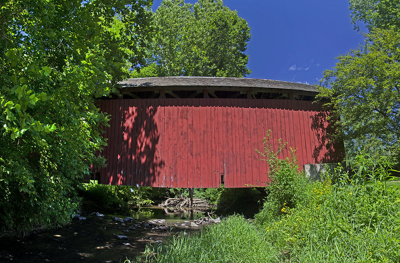
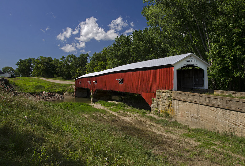
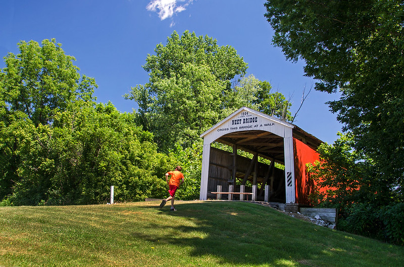
Six miles southeast of Rockville, Indiana, stands the Neet Covered Bridge. Said to be the last covered bridge built by Joseph Daniels (a well known covered bridge contractor) the 126 foot long bridge has spanned Little Raccoon Creek since 1904.

Neet Covered Bridge Interior

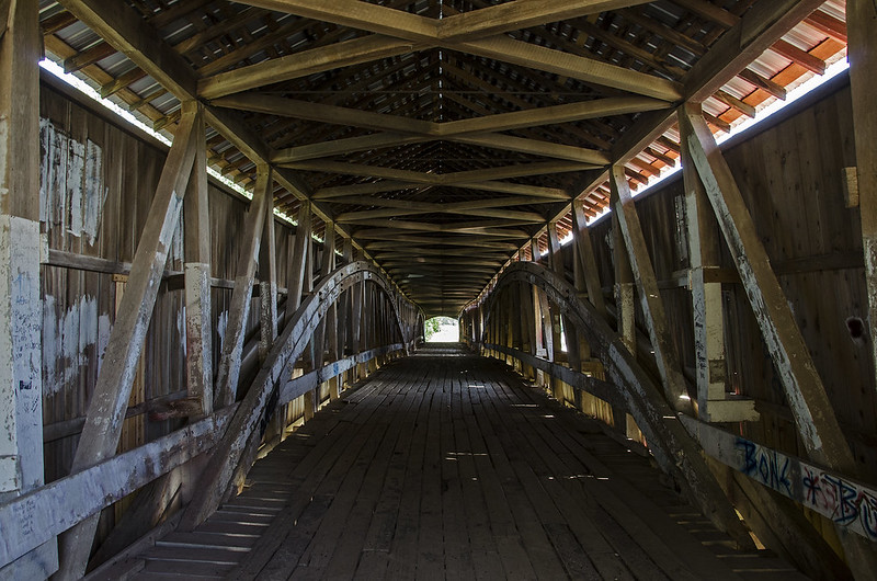
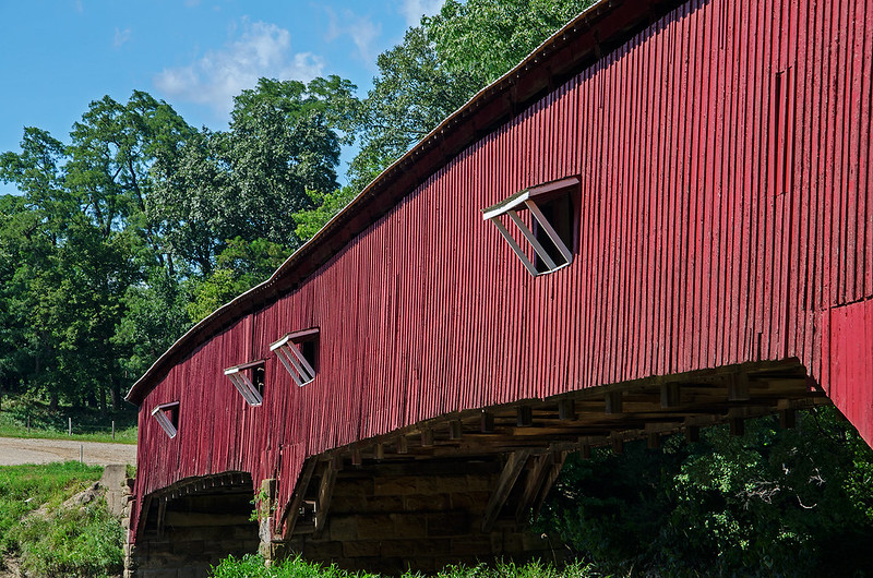
Windows were often built into these structures when the road curved near the bridge. The windows allowed persons crossing to view any traffic approaching the bridge from the road ahead.  This explains why windows were often only on one side of the bridge, and sometimes only on one end.

Neet Covered Bridge Entrance

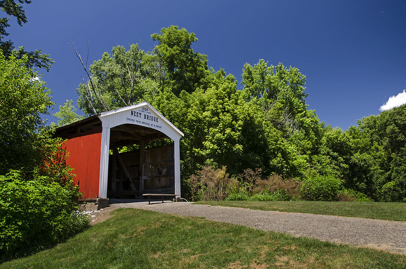
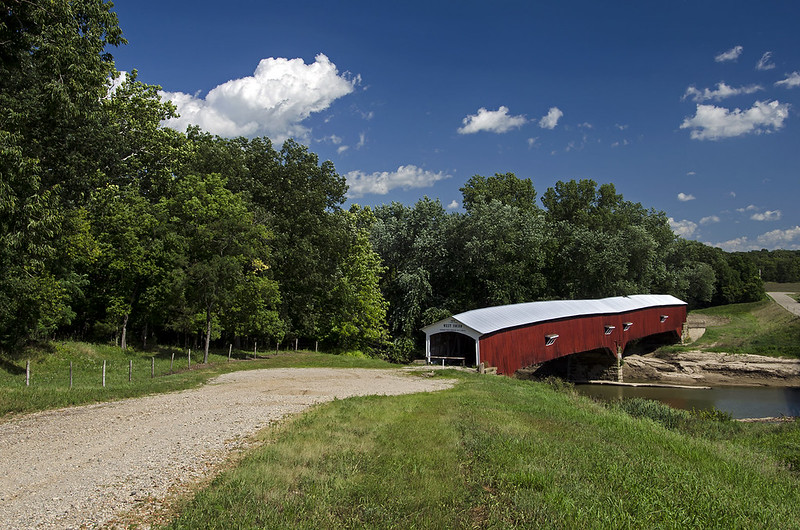
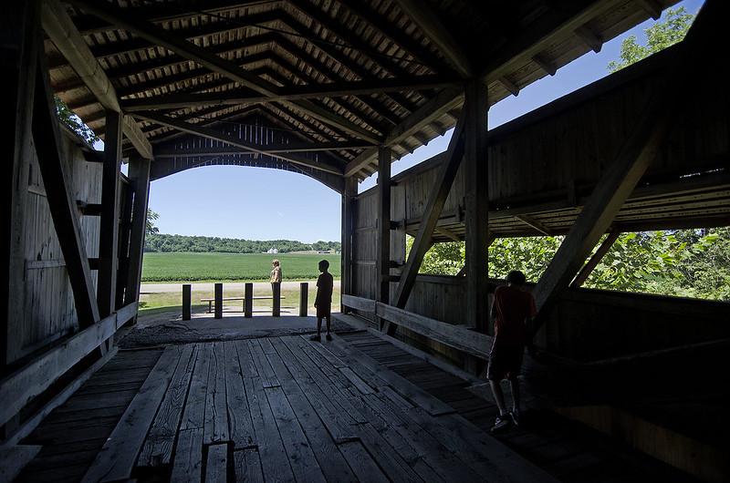
Closed to vehicular traffic today, the Neet Covered Bridge makes the perfect little rest stop when driving or biking this lonely section of Bridgeton Road. While resting, visitors can enjoy the historic bridge and the beautiful views of the countryside.

A Covered, Covered Bridge

Covered Bridge
Partially obscured by trees, the 92 foot long Mill Creek Covered Bridge almost becomes part of the surrounding landscape. Still in use on Towpath Road, 2-1/2 miles from Tangier, Indiana, the 1907 structure spans  Mill Creek at a point once called Thompson's Ford (a ford is a shallow area of a creek or river which is often used for crossing). This area was very close to the historic Wabash and Erie Canal, hence the name Towpath Road, and a third name for the bridge: Tow Path Bridge.

A Tree Covered Bridge

A small village once existed near this bridge; within it, a flour mill operated for several years.  The dam for the mill washed away in 1888, and was never replaced.  There are no remains of the village today.

The creek beneath this bridge is quickly eroding the bank, forcing some structural enhancements over the last few years. Nonetheless, the bridge remains open to traffic.

The Beeson Bridge

Walking the Beeson Covered Bridge
<
Originally built 1n 1906 across Big Raccoon Creek, the Beeson Covered Bridge was rescued and moved to it's current location over Williams Creek. The bridge is no longer open to vehicular traffic, but serves as the entrance to Billie Creek Village, a collection of historical buildings including a general store, log cabin, church, and print shop.

hidden bridgesm

The Beeson bridge is a single Burr Arch spanning 55 feet, constructed of wood on a concrete foundation.Named after the family whose farm was located near the bridge, the Beeson covered bridge was reunited with the family log cabin when it was moved to Billie Creek Village in 1979.

<Shady Bridge
<

100 Years - The Bowsher Ford Covered Bridge

Bowsher Ford Bridge

Carrying traffic over Mill Creek, the Bowsher Ford covered bridge celebrates her 100th birthday this year. Built in 1915 by Eugene Britton, the bridge resides on a gravel road about two miles northwest of Tangier, in rural Parke County, Indiana.  A single Burr Arch span of 75 feet, this covered bridge differs a bit from most in Parke County, as it has a concrete foundation instead of cut stone.

Bowsher Ford

Named after the Bowsher family who owned the farm near the ford (a shallow spot on the creek used for crossing),  The bridge remains in a remote part of the county, surrounded by woods and farms, and is listed in the National Register of Historic Places.

Bowsher Ford Approach

Parke County, Indiana hosts the Covered Bridge Festival, a celebration of the 31 remaining covered bridges throughout the county. The festival begins each year on the second Friday of October, and runs for nine days. What began as a small gathering back in 1956, has grown into a county-wide festival attracting over 2 million visitors to the county each year.

For the other 51 weeks of the year, it seems most of the covered bridges in Parke County remain quiet and isolated in their rural surroundings.

West Union Covered Bridge

West Union Covered Bridge

Spanning Sugar Creek since 1876, the 315 foot long West Union covered bridge is the longest (still standing) covered bridge in Parke County, Indiana.
Located in the west-central portion of the state, just north of Terre Haute, Parke County is known as the "Covered Bridge Capital of the World", 31 Covered bridges remain standing in the County - many are still open to traffic. Compare that to Madison County, Iowa (made famous by the 1995 film The Bridges of Madison County), which only boasts six covered bridges.

West Union Interior


The West Union covered bridge was built by Joseph Daniels, and uses double Burr Arch construction - one for each span. The foundation is constructed of stone, the bridge of yellow poplar, and the roof painted steel. The construction cost was between $8,000 and $16,000.

West Union Windows

Sugar Creek flows beneath the bridge, and more water passes under this bridge than any other covered bridge in the county. Closed to traffic since the 1960's when 10 O'clock Road bypassed the bridge, pedestrians can enjoy a leisurely walk across the spans while enjoying the quiet, rural setting.

West Union Covered Bridge 2

Hiking to the Bunkers

Hiking to the Bunker

At nearly 30 square miles, Midewin National Tallgrass Prairie has plenty of grassy trails to explore.  Some of the most interesting wind through vast lines of abandoned bunkers.  These grassy mounds stand out from the flat, Illinois landscape, but blend in well from afar. Once used to store materials used to make explosives during World War II, the soil covered, concrete bunkers remain - too expensive and difficult to remove.

Midewin sits on the site of the former Joliet Arsenal which once employed over 10,000 workers, and produced 1 billion tons of TNT for the war effort. According to the USDA information, the site includes 373 ammunition bunkers, 429 structures, 78 miles of paved roads, and 110 miles of railroad. These are all slated for demolition and removal when money and time is available. The magnitude of the site is evident as one walks through the bunker fields - this place is huge. The bunkers were set hundreds of feet apart just in case an explosion occurred, other bunkers would not ignite. To pass all of the bunkers in a single trail would take hours.

Loop 63 Bunker

For now, a few of the bunkers are open for viewing. They are rather interesting to enter.  Only a single, heavy steel door leads in and out. No windows or emergency exits, the bunkers are dark, damp, and sounds inside have an unreal echo.

Inside the Bunker

Worth a trip just to view the WWII ammunition bunkers, but expect a long hike. Bring your hiking shoes, some water, and plenty of tick repellent!

Cicada Killer

Cicada Killer A cicada wasp drags home her large prey, which can take the better part of a day. Emerging in mid to late July, the cicada wasps relentlessly hunt the noisy cicada. Harmless to humans, the male cicada wasp cannot sting, and the female wasp is only interested in cicadas. You can find these wasps easily by their mounds of sand or soil. Mounds in lawns or gardens approximately 8 inches in diameter at this time of year are often signs of the burrows of the cicada wasp. The wasp digs these burrows, then hunts for a cicada. Once found, the wasp stings the cicada to paralyse it, then drags it to the burrow. Weighing twice as much as the wasp, this is often a difficult task, but eventually, the cicada is brought underground where it will lay alive for weeks. The wasp then lays an egg near the cicada - it will serve as food once the egg hatches. If you see a wasp measuring 1 1/2 to 2 inches in length flying around, don't worry - they're not interested in humans. They may fly around you to see what you are, but as long as you're not a cicada, there's nothing to worry about.

Heading Out

Heading Out The boys heading out into a flat calm Lake Michigan on a still summer morning. The weather has been pretty wet around the Midwest this year, and along with the moisture came plenty of storms. These storms really churned up the lake, creating high waves responsible for eroding the beaches along the Indiana shore. Here we were experiencing the calm between the storms, as more severe weather was predicted later in the day. It's hard to beleive they were walking into a lake that reaches 920 feet deep, and has some (if not THE) most powerful waves of all the world's fresh water lakes. Lake Michigan's length runs north and south, providing hundreds of miles of open water to build intense waves during storms.

Sculpted Dune

Sculpted Dune

The dunes along the Indiana shore of Lake Michigan take a pounding by the waves during windy days. In the last few years, this erosion seems to have accelerated; much of the flat beach is gone, and full sized trees that once stood on the dunes have been washed into Lake Michigan.

Once portions of the dune collapse, they are no longer covered in vegetation, and the sand is easily washed away by rain and wind.  Ever changing, the dunes are never the same twice, and on this early summer morning the patterns in the sand were striking.

Sand Sculptures

Looking like miniature versions of the buttes of the western United States, the complex patterns intrigued us as we hiked along the shore.

There's always something new and interesting to discover while hiking The Indiana Dunes National Lakeshore.

Sunset on the Farm

Sunset on the Farm

The end to a long day of hiking around rural Illinois was made perfect by this sunset near an old log cabin on the prairie. The light was no longer acceptable for images of the cabin, but the setting sun, windmill, and trees on the horizon yielded some great silhouettes.

Temperatures dropped dramatically right as the sun hit the horizon, and storms were on the way, but we managed to complete our photographic mission without encountering any rain.

Enjoying the Falls

Giant's Bathtub

Illinois' Matthiessen State Park packs plenty of scenery in its mile-long upper and lower dells trail. At least seven waterfalls wait for exploration in this narrow canyon covered by trees from the woods above.

The largest pool of water is the Devil's Bathtub, just below a cascade of two waterfalls. (pictured above)  A few meters beyond is Lake Falls, at around 35 feet tall.  To walk from one to the other, visitors must step in the stream at the top of the falls to Devil's Bathtub - the stream is only two or three inches deep at this point, and perhaps 5 feet wide, so not a large obstruction.

The trail running along the top of the dells is wooded, but doesn't offer too many views of the canyon below, however, there are a few points leading down to the dells if one prefers not to walk in the often muddy trails along the stream.

Less crowded than it's larger sister, Starved Rock State Park, Matthiessen offers quite a bit of interesting scenery not found in too many places in Illinois.

Severe Weather

Illuminated Clouds

While the storms never reached us, the distant lightning and overhead mammatus clouds kept us intrigued throughout the evening.  A cold front just south of our position, stalled, and produced some severe thunderstorms that just didnt' seem to move away.

Mammatus Clouds

Just before sunset, mammatus clouds appeared overhead, spun off from the thunderheads a few miles south. Almost constant thunder could be heard in the distance as we looked above at the unusual puffy, clouds.

Usually, mammatus clouds last for a few minutes, as the storm approaches, but on this evening, they stayed for at least two hours, perhaps longer as we could no longer see them after dark.

Lightning Bolt

The storm continued into the late evening. Around 10pm, constant flashes of distant lightning to the south kept us watching the horizon. Aside from the streaks of lightning, the illuminated clouds interested me even more.

Peaceful Sunset

Peaceful Sunset

The end to a beautiful spring day in rural America.

Hoping to arrive at our destination before the sun set below the horizon, I was a bit disappointed the sun was too low to illuminate the landscape.  The distant trees blocked the light, and the subjects that I intended to photograph during the "golden hour" were now in shadow.  Looking around a bit, I noticed the sun on the horizon, filtered by high, wispy clouds; providing the perfect back lighting for a great silhouette- especially next to the distant windmill.

Sometimes the landscape dictates what's going to happen, and when you listen, the outcome is usually better than the one you planned.

Dark Falls

Dark Canyon Falls

Early morning at the bottom of the canyon was quite dark, even though the sun illuminated the falls and the trees some 30 feet above us.  We spent the morning following trails we normally don't explore, and encountered some interesting new landscapes, but we came back to visit one of our favorite waterfalls.

At around 30 feet, Lake Falls, is the tallest waterfall in Matthiessen State Park, and one of the most popular.  It's relatively easy to view from the trail above, or the bottom of the canyon, but if you wish to get close to it, you'll probably get your feet wet.  If you know where to park, this waterfall is only a few steps away from your car - great for freezing cold days when you wish to view the frozen waterfall but don't want to hike in the cold.  The best way to experience this fall is to hike in along the stream from the main parking lot. You'll experience a few other waterfalls, and wander through plenty of moss covered canyon.


Beyond the Falls at Cedar Point

Beyond The Falls of Cedar Point

I've explored and photographed the falls just beyond Cedar Point in all seasons, but I especially love these falls in winter.  The slow trickle of water freezes across the entire surface of the canyon ledge, creating an ice cave large enough to enter.  The image below shows the waterfall beyond Cedar Point. The photo above shows what lies further upstream - above the waterfall.

Falls Near Cedar Point

In winter, the path through the canyon turns to ice, so it's very difficult to walk the trail above the falls.  I always wondered what features were above these falls, but I didn't expect several more small waterfalls.  On this day, we followed a narrow trail up the side of the canyon, and onto the top of the falls, where the path led us to more waterfalls and interesting canyon features.

An interesting morning exploring some of the lesser known canyons and waterfalls of the park.

Parallel To Shore

Parallel To the Shore

Kintzele Ditch runs parallel to shore on this day, virtually eliminating all of the beach on the Mt. Baldy side of the stream. Lake Michigan has eroded most of the beach over the years, and collapsed a good portion of the foredunes in this area of the National Lakeshore.

Despite predictions for cold weather and rain, the beach was very comfortable on this morning.  The cold front rolled in a bit later, bringing with it rain and much colder temperatures.  A wall of fog can be seen on the horizon over Lake Michigan; it slowly made it to shore, as we left the beach.

fog2sm

fogsm

Dividing the Dunes

Dividing the Dunes

Kintzele Ditch flows into Lake Michigan from the waters of the Great Marsh, a 10 mile long wetland just behind the large sand dunes along the shore.  The two dunes it divides appear drastically different from one another - one is rather bare, while the other is lush with trees and vegetation.  Lake Michigan is slowly wearing away the beach, and collapsing the dunes little by little.  With each collapse, grass and full grown trees fall onto the beach, and are washed away by the waves of the lake.

The dune at the left has seen some major erosion over the past few years (not to say it was completely covered with trees previously), most of the front of the dune is gone. This erosion is evident on the lakeside surface of the dune at the right. Once covered in shrubs and trees, many have fallen victim to waves and gravity.

This panoramic image is composed of eight photographs stitched together. The effect gives an interesting vantage point to the stream and dunes.

Convergence

Convergence

So many things converging in this image. The land with the water; the stream with the lake; grass with the sand; dunes with the beach; sky with water; nature with industry; steam with clouds, and warm and cold weather.

A morning with warnings of rain, wind, shoreline flooding, fog, and cold temperatures, was tolerable for the most part, and seems to have scared everyone off the beach - we were the only ones in sight.

The gloomy morning enhanced the mood of the industry on the horizon - Michigan City's electric plant, with the landmark cooling tower allowing steam to touch the clouds.

Moments after this image was captured, a line of clouds appeared on the horizon as far as the eye could see.  Knowing the predicted storms were on their way, we hastily headed the 1/2 mile to the parking area.  The wall of clouds quickly moved toward us, and with no way of making it to shelter, we readied ourselves for a drenching.

Much to our surprise, as the clouds approached, and the cold winds hit us, the wall of clouds turned out to be fog - no rain.  The beach ahead of us and behind us disappeared, as did the tops of the dunes, as the thick fog rolled in off the lake.

The weather created an almost surreal view of so many things converging at one time.

Established Dune

Established Dune

Parallel to the shore of Lake Michigan, this sand dune seems well established - supporting a wide variety of vegetation.  Grasses, flowers, shrubs, deciduous trees, and even a small stand of conifers thrive on the dune.  The foot of this dune touches the beach, without a prominent fore dune, allowing the crashing waves to reach it during storms. At least once in the past, a storm eroded a portion of the dune, collapsing a large area.  You can see evidence of this collapse at the right of the center dune in the photo above.

Without natural sand replenishment, Lake Michigan is slowly eroding away these dunes. Man made structures such as the pier in Michigan City, prevent waves from carrying sand to this beach, so a prominent fore dune has not developed.  Without a fore dune, this established dune is threatened by wind and waves.

Dunes a bit closer to Michigan City, near Kintzele Ditch, have all but lost their vegetation on the lake side of the dunes.  These dunes are eroding at an alarming rate, as the waves wash away the sand, collapsing the dune, taking mature trees with.

The dunes are an ever changing feature along the shore of Lake Michigan. They've changed every day for the last 4000 years, and won't stop anytime soon.

Marsh Patrol

Marsh Patrol

Restoration continues in the Great Marsh of the Indiana Dunes National Lakeshore. Efforts seem to have positive results - plenty of wildlife are calling this place home.  On our last visit, we encountered numerous species of bird, water birds such as the egret in this image, several great blue herons, turtles, frogs, and lots of insects. All without looking too closely.