Fall on the Prairie

Fall on the Prairie

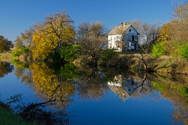
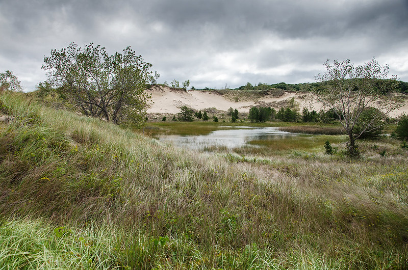
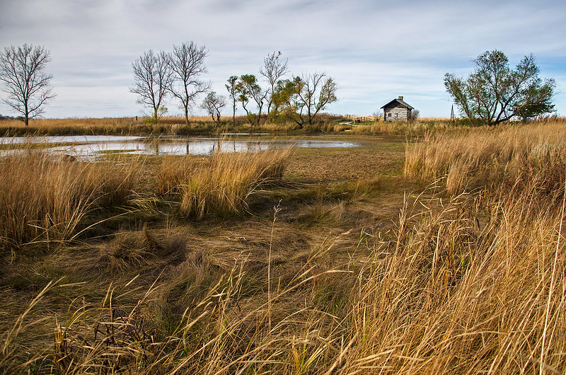
Late afternoon at Goose Lake State Prairie, and the signs of Autumn are everywhere. What was once lush green tallgrass, sprinkled with wildflowers, is now brown and mangled, ready for the changes and cleansing of Winter.

At 2,500 acres, Goose Lake Prairie is the largest prairie remnant in Illinois. A great portion of "The Prairie State" once looked much like this.  Early settlers drained the 1,000 acre Goose Lake in this spot, and removed the clay for pottery and brick making. Coal mining took place in the 1800's, and much of the surface land was scoured.

Today, the prairie appears much as it did before the settlers - minus the lake - with a mound of soil from mining times that offers the highest vantage point in the park.

St. John Cantius Parish

St John Cantius Interior

Completed in 1898, the "Polish Cathedral" style church is a remarkable example of sacred Baroque Architecture. A thriving parish today, the church draws thousands to worship each week. Masses are celebrated in both the Ordinary Form, as well as the Extraordinary Form, in English and Latin.

Altar of St. John Cantius

St. John Cantius offers the daily Holy Sacrifice of Mass in the Extraordinary Form, often called the Tridentine Latin Mass.

St. John Crucifix

On this All Souls Day, the parish offered a Pontifical Latin High Mass including the Mozart Requiem, sung by the choir with orchestral accompaniment. No microphones were used for the Latin Prayers, some said at a whisper, adding a mystery to the service, but really, this is the time for the congregation to meditate on the former parts of the Mass.

Balcony View

St. John Church

The 2 hour and 15 minute Mass was filled with tradition not regularly seen in Catholic Churches today, such as kneeling at the Communion Rail for the Eucharist, and the use of patens by the altar servers to catch any particles of the Host that may drop.

Entering St. John Cantius

St. John Cantius is located in Chicago, just one mile west of the famous Chicago Water Tower, and the Magnificent Mile.

Crucifix

St. John Altar

Colorful Reflections

Colorful Reflections

A peaceful walk on the Hennepin Canal towpath is enhanced by the low, late afternoon sun, and the colorful leaves of Autumn. Located a couple of miles outside of Wyanett, Illinois, Lock 20 was the location of a lock tender's home.  This lock tender served Lock 20 and 21, which are both in very close proximity to one another.

Today, the house is vacant, and in ruins. If you believe in such things,  it is also said to be haunted, or at least some supernatural events have been experienced by locals.

The Hennepin Canal runs from the Illinois River to the Mississippi River, thus linking Chicago to the Mississippi, and ultimately to the Gulf of Mexico. Completed in 1907, it was the first major American canal made with concrete, and due to the success of railroads, it was obsolete the moment it was built.

Autumn Afternoon

Autumn Afternoon

The Princeton, Illinois covered bridge on a warm, sunny autumn afternoon. The changing leaves provided the perfect backdrop to the historic structure.  Built in 1863 over Bureau Creek, the 149 foot long bridge remains open to vehicular traffic.

Under the Covered Bridge

A small park is located at the foot of the bridge, allowing visitors, to use the area for picnicking, playing, photography, and fishing. A narrow path gives access to the creek for exploring. Kids love skipping rocks, fishing, and catching frogs under the old, wooden structure.

Heading Up

Heading Up

The 3.4 mile Long Lake Trail is one of three trails at the Indiana Dunes National Lakeshore's West Beach. The loop begins with an ascent up a sandy dune, and follows the dune ridge through the rather dense woods first bordering the beach, then overlooking the grass of the Great Marsh.

The second half of the loop follows the foot of the dunes past Long Lake, and through the grassy, flat areas filled with prickly pear cactus, and pitcher's thistle.  You might even spot a few six lined racerunner lizards in the summer months.

This trail is one of the few places at West Beach one can still hike up a sandy dune - something that is becoming increasingly rare at the Indiana Dunes National Lakeshore (all in the name of erotion prevention). It seems to me that blocking off the paths through the dunes does very little execpt create more erosion due to ignorant visitors walking around the signs and fences. Instead of one path, many more are created, and in the process, more and more plants are trampled adding to the problem.

If the traditional paths are left open to those who have walked them for decades, as well as new hikers, not only will visitors enjoy them, new, destructive paths won't become a problem.

Instead, visitors can admire the dunes from the asphalt parking areas, and tell their grandchildren storys of how they once walked on top of the dune.

Lake Willowmere

Lake Willowmere

Autumn color reflected in the still waters of Lake Willowmere, inside Chicago's Graceland Cemetery. A picturesque and calm final resting place for many of Chicago's famous people.  A walk through the cemetery yields familiar names such as Louis Sullivan, Marshall Field, George Pullman, McCormick, Kimball, Newberry, and Goodman.

Reflected in the lake, stands the tomb of Potter Palmer, the businessman responsible for most of the development of Chicago's State Street.

The 119 acre Graceland Cemetery, once stood two miles outside Chicago's boundary. Now surrounded by the city, and only a stone's throw from Wrigley Field, the cemetery is open for the public to view the magnificent memorials to Chicago's rich and famous.

On a Clear Day....

On a Clear Day You Can See Chicago

...You can see Chicago.  From atop the tallest sand dune of West Beach, Chicago is 28 miles across the lake; easily seen on a clear, crisp day.  This morning was the coldest in six months, yet the cold air or high winds didn't keep us from hiking the progression trail, taking us from the beach to the top of the wooded dunes, where the urban skyline became a backdrop to the natural environment around us.

We were greeted by a cold wind as we approached the top of the dune, reminding us of the winter ahead, and how most of our trips to the beach for the next few months will require plenty of warm clothes and a bit of determination to get to our destination.

Day's End

Day's End

The calm end to a windy, Fall day in rural LaPorte County, Indiana. It seems at times when the sunset is obscured by clouds, it's best to wait about 20 minutes after sunset to photograph the sky.  The colors are often vibrant for a short time, and when combined with the still waters of a lake, the reflections can be just as brilliant.

It was a fitting end to a day of hiking the Indiana Dunes, the remains of the Kingsbury Ordinance Plant, and some areas around our property.

Everything seems to calm down in the evening here - no matter how busy or windy the day was.

Stargazing

Stargazing

Following a full day of hiking and exploring new places, we stopped at the beach just before 11pm. Because the moon was out of sight, the sky was relatively dark, allowing the stars to shine through. As usual, light pollution from Chicago affected us 40 miles across Lake Michigan, but along with the high, whispy clouds, it added interesting light and color to the horizon.

You can see the Chicago skyline on the horizon - no fireworks this time, but sometimes we watch the colorful blurs of distant fireworks launched from Navy Pier.

We gazed up at the stars, watched the airplanes taking off from Chicago, and wondered what made the sounds in the woods behind us.


A Taste of Fall

Fall is in the Air

Giving us a taste of what's to come, the blustery weather kept most people away from the beaches on this cold morning. In fact, we were the only people there. The high winds continued from the day before, eroding a lot of the sand from the beaches, exposing many interesting rocks and fossils.

Even though I enjoy hot weather most, days like these are some of my favorite. We can experience nature by ourselves, with no other human distractions.  It's interesting how civilization is just a mile or two away, but if you look around, you don't see anyone - you're seemingly in the middle of nowhere. Very cold winter days are very similar, except the blanket of snow often muffles the sounds of nature, making it seem even more remote and tranquil.

The beaches will fluctuate from summer-like to blustery until November, giving us an opportunity to experience the last of summer, and a taste of the bitterness of the winter to come.

Interdunal Pond

Interdunal Pond

One of the interdunal ponds of The Indiana Dunes National Lakeshore's West Beach, on an overcast morning. These ponds form between two dune ridges, when water is unable to flow away, or drain into the earth.  These wetlands are a haven for a number of creatures including waterbirds, frogs, and insects, plus they provide water for many forest creatures.

Some of these ponds are hidden quite well from view, especially if they're off the beaten path, just over a distant dune ridge. In that case, the wildlife is more plentiful, as humans don't frequent the area. These areas can give one the feeling of being far removed from civilization, even though cars and trains are just a few hundred feet over the ridge.


Calm Summer Morning

Calm Summer Morning

Two boys play in an unusually calm Lake Michigan on a hot summer morning. Throwing stones into the lake, skipping rocks, and hunting for fossils were the top activities of the morning.

Two of the most popular beaches have been closed this summer - Mt. Baldy (closed to the public since 2013), and Central Beach (closed since July). This puts a lot of pressure on the few beaches left - visitors must arrive before 10 am for a chance at a parking space.  The beaches themselves do not seem overcrowded, since there is little parking available.

With any luck, the two beaches will reopen next year, allowing visitors to walk once again on the sands of Lake Michigan next to the wooded sand dunes.

Harry Evans Covered Bridge

Harry Evans Covered Bridge

The 65 foot long Harry Evans Covered Bridge spans the small Rock Run Creek 1/2 mile from the town of Coxville. This bridge is still open to vehicular traffic on this out-of-the-way gravel road, but a concrete ford built just downstream allows larger farm vehicles to cross the creek.

Through the Bridge

Built in 1908 using a single span Burr Arch design, the bridge gets its name from the farmer who owned the land near the bridge at the time.

Harry Evans Covered Bridge

This covered bridge was in the most peaceful area of all the bridges we visited.  So remote and quiet, we could have spent hours with our feet in the creek and probably would not have seen another person.

harryevansspansm

Summer Skyline

Summer Skyline

A jetskier enjoys the waters of Lake Michigan - just off Monroe Harbor- on a hot summer afternoon. One of the best places to view the Chicago skyline if you're a land lubber is from Solidarity Drive and the breakwater around the Adler Planitarium.  The skyline is clearly visible, behind Grant Park, and the lakefront trail, with Monroe Harbor in the foreground- an all around great combination.  It's best to arrive early in the day when the buildings are washed with sunshine, or after sunset when they are illuminated.  Anytime near sunset the buildings will be in shadow because the sun sets behind them.

Many years ago, I used to walk out on the Easterly Breakwater to view the city, but the last few times I've tried to access it, it's been closed.


Meteors and the Milky Way

Milky Way with Meteors

A dark summer night in rural LaPorte County, Indiana presented a great opportunity to view the Milky Way Galaxy.  The crescent moon hadn't risen yet, so the sky was very dark - except for the light pollution from big cities many miles away.

While gazing up at the stars, we noticed a meteor or two traverse across the sky, so I was hoping my camera captured one or two.  I used exposures from 10 seconds to 20 seconds, and in the photo above, found four meteors, one very difficult to see unless zoomed in.

Milky Way

At first, I thought the light streaking at the bottom left was an airplane, but in a 20 second exposure, the light would have appeared like a zipper, with dots every second as the plane's lights flashed.

I remember staring up at the sky on a warm summer night as a high school kid, in a rowboat in the middle of a small lake, and viewing the Milky Way. Shading my eyes from the lights on the shore, and letting them adjust to the darkness.  It seemed the longer I looked up, the more stars I saw. I was able to experience that same feeling again last night.

The Mecca Covered Bridge

Mecca Bridge Spanning Big Raccoon Creek since 1873, the 150 foot long Mecca Covered Bridge is a historical centerpiece of the small town of Mecca, Indiana. Once called Maidstone, the town may have been renamed after a group of Syrian Muslims settled the area and frequented the mill on Big Raccoon Creek. The Bridge to Mecca The bridge is no longer open to traffic, US 41 passes a short distance away from the town, but the residents adore their covered bridge. The bridge is decorated for Christmas, and caroling takes place inside. At Easter, a sunrise service is held in the bridge. We noticed old electric lights inside the bridge - no doubt easily added due to the proximity of "modern" electric lines so close to the bridge. Gazing out the Window The bridge contained a single window allowing people crossing the bridge to view oncoming traffic on the curving road ahead. A small park including an old schoolhouse are on the grounds, making this covered bridge easily accessible for drivers who wish to stop and explore the bridge without blocking traffic. Mecca Covered Bridge

Roseville Covered Bridge

Roseville Covered Bridge This 263 foot long covered bridge is the third bridge built across Big Raccoon Creek at this site. In 1910, the previous bridge burned and a concrete bridge was considered as a replacement. Instead, the Roseville covered bridge was constructed, and remains today. Not far away in Armiesburg, a concrete bridge was built in 1917 to replace the wooden covered bridge, it collapsed after only 13 years! Roseville Covered Bridge The Roseville covered bridge uses two Burr Arch spans to cross the creek, and has a cut sandstone foundation. It's set on a gravel road, in an out of the way portion of Parke County, and only a block away from a very small cafe and bakery, very easy to miss while driving on adjacent Coxville Road. The local people seem to care for this bridge - an assortment of colorful flowers grows near the entrance.

Bridgeton Mill and Covered Bridge

Bridgeton Covered Bridge and Mill Indiana's most famous covered bridge, is the 267 foot long, double span Burr Arch bridge in the historic town of Bridgeton. Adjacent to the old Bridgeton Grist Mill, the original bridge was built by J. Daniels in 1868. Destroyed by arson in 2005, the community gathered to rebuild the bridge using the original plans and traditional materials and methods. The current bridge was completed in 2006. Bridgeton Mill and Covered Bridge The bridge spans Big Raccoon Creek at the dam constructed for the mill. The flow of water over the nine foot tall, 220 foot wide dam is usually contained to only a portion of the dam, but in high water situations such as in the photo above, the water cascades over the entire structure. The oldest operating grist mill in Indiana, and possible the entire region, Bridgeton Mill has operated in some way for the past 180 years - from milling wood to grinding grain. Open today for demonstrations, visitors can watch as grain is milled to flour using the 2000 pound French Buhr stones, and feel the floor vibrate as the massive stones turn. Bridgeton Bridge Approach Certainly one of the most interesting covered bridges in Parke County, Indiana.

The Neet Covered Bridge

The Neet Covered Bridge
Six miles southeast of Rockville, Indiana, stands the Neet Covered Bridge. Said to be the last covered bridge built by Joseph Daniels (a well known covered bridge contractor) the 126 foot long bridge has spanned Little Raccoon Creek since 1904.

Neet Covered Bridge Interior

Windows were often built into these structures when the road curved near the bridge. The windows allowed persons crossing to view any traffic approaching the bridge from the road ahead.  This explains why windows were often only on one side of the bridge, and sometimes only on one end.

Neet Covered Bridge Entrance

Closed to vehicular traffic today, the Neet Covered Bridge makes the perfect little rest stop when driving or biking this lonely section of Bridgeton Road. While resting, visitors can enjoy the historic bridge and the beautiful views of the countryside.

A Covered, Covered Bridge

Covered Bridge
Partially obscured by trees, the 92 foot long Mill Creek Covered Bridge almost becomes part of the surrounding landscape. Still in use on Towpath Road, 2-1/2 miles from Tangier, Indiana, the 1907 structure spans  Mill Creek at a point once called Thompson's Ford (a ford is a shallow area of a creek or river which is often used for crossing). This area was very close to the historic Wabash and Erie Canal, hence the name Towpath Road, and a third name for the bridge: Tow Path Bridge.

A Tree Covered Bridge

A small village once existed near this bridge; within it, a flour mill operated for several years.  The dam for the mill washed away in 1888, and was never replaced.  There are no remains of the village today.

The creek beneath this bridge is quickly eroding the bank, forcing some structural enhancements over the last few years. Nonetheless, the bridge remains open to traffic.