Arctic Volcanos

Ice Volcanos On Lake Michigan

Looking much more like the arctic than Indiana, a walk on the Lake Michigan shore during winter offers some interesting ice formations one normally associates with seascapes of the North. As the wind stirs up Lake Michigan, the waves pound the shore and pile up the floating ice into cone-shaped mounds resembling volcanos. The physics is actually rather similar, at least when it comes to the construction of the cone. When the waves pound against the shore or other shelf ice, waves force water and ice chunks into the solid structure where they splash up and fall onto the shore in a pile. This happens over and over again until the pile forms a cone around the area where the ice and water is splashing vertically. The center often remains hollow, a tube that transports the ice and water to the surface. Volcano cones are formed in a similar way, but by hot lava and molten rock spraying up, not ice. 

Walking along the shore during the windy periods is something to experience as well. When hiking down the sand dunes onto the beach, almost all sounds disappear when you reach the area that is sheltered by row after row of ice mounds. You're basically walking in a hallway with ice mounds on one side, and sand dunes on the other. The only sounds are the muffled splashes of the distant waves continuing to build additional mounds.
   Arctic-like

Hiking down to Kintzele Ditch, some of the shelf ice is covered by frozen ponds formed by the always-flowing creek. These icy areas take on the look of ponds, and seem to mimic an arctic seascape where icebergs are scattered in the frozen waters - mounds among smooth ice. These features and forms of the ice are ever-changing, and worth a visit or two each winter.

Matthiessen's Ice Cave


Double Falls

One of the highlights of the winter season is the freezing of the waterfalls of Starved Rock and Matthiessen State Parks. While the amount of seasonal moisture certainly affects the size and shape of Starved Rock's icefalls, the icefalls of Matthiessen State Park are almost always fully formed regardless of  precipitation. I believe this is due to the fact that the creek feeding the falls is always flowing and not fully dependent on the snow melt or rain. This makes for great icefalls in the winter. 

One of our favorite areas of Matthiessen is the canyon beyond Cedar Point. To visit this area, one needs to cross the creek, and at times, this can be a challenge. Some years it's flowing knee deep, other years it's frozen solid, this year it was frozen but had quite a bit of "rotten" ice on top due to overflow. Overflow is when a body of water freezes over, but the level of the water later rises and overflows onto the top of the ice. New ice forms, but it's not stable, and walking on the ice can be a hazard if that overflow ice breaks- here we would only get our feet wet, so it's more of a nuisance.

Once across the stream, two waterfalls appear in the distance, and both usually freeze up with plenty of space behind them, creating ice caves. At just the right time, one can relatively easily get behind and explore. Wait too long into the season and the opening will be too small to climb through.
  Inside the Matthiessen Ice Cave

This year, we hit it at the right time. The ice was covering the overhang of the canyon forming a cave, the openings were accessible, and the floor of the cave was frozen and not filled with water. It's an experience to venture into these caves, the ice is so interesting when it's backlit. Without ice cleats, it would be quite difficult to access these caves, and at times, impossible to even access the icefalls because of the slippery approach.
  Exiting the Ice Cave

The rock overhang that makes these ice caves possible, is almost six feet tall, so when the ice forms on the floor, there's a ceiling of about five feet in some places, on down to four feet. Still, it's quite easy to access if you don't mind a bit of squeezing and climbing. Getting out is sometimes sketchy, but this year, the opening on the left side of the cave was large enough to walk through. Some years only one side is large enough, and the right side requires traversing over round, icy rock - something that's more difficult leaving than entering.

The Ice Barrier


Ice Barrier 
The period of cold, windy weather over the last few weeks provided the perfect conditions for the formation of shelf ice along the Lake Michigan shoreline. As the water freezes, the wind and waves push the ice chunks toward the shore where they pile up and freeze together with the water splashes an spray. Over time, the ice builds up higher and higher, and the mounds grow up and out, creating an arctic-like range of ice hills parallel to the shore.
  Shelf Ice Detail 
Walking carefully along the beach (on solid ground not ice) looking at the formations of the mounds and the flat areas between them, one feels as if they're in the arctic instead of Indiana. Winter at the Indiana Dunes National Park is like nowhere else in the state, a treasure for certain.
  Mounds of Shelf Ice

The French Canyon Icefall


French Canyon in Winter

On our hike through Starved Rock State Park, we ventured down the icy steps toward French Canyon, a blind canyon with a cascading waterfall at the terminal end of the trial. 

The narrow passages are sometimes difficult to walk over in wet weather, but rather treacherous when iced over. Of all the places to visit at Starved Rock, this is the only one with signs warning of the dangerous icy conditions. Other canyons have steep drops and ledges which you'd think would be more dangerous, but this canyon can fool people because of it's innocent looking approach. So many people attempt to walk up the trail and either fall or give up. It's trails such as this that demand the use of ice cleats, and wearing them, one can simply walk up the icy approach with no concern. 

The waterfall in French Canyon does not freefall, it travels over the rock face and, in cold weather, the ice covers the entire surface, creating a beautiful ice staircase up the canyon wall. Of course at 45 feet high, it's too tall and too dangerous to use as a staircase, but because of this geography here, this waterfall almost always guarantees a beautiful formation of ice.

  Frozen Falls

A few years back, a couple of trees fell into the creek, and ultimately into the canyon; these logs remain at the foot of the falls. The logs now act as a centerpiece on the canyon floor, adding some natural interest to the waterfall. 

On this visit to Starved Rock, French Canyon's frozen waterfall was the most impressive of all the canyons we visited. Perhaps this will change once the current snow melts and refreezes while falling down the other rockfaces.

LaSalle Canyon's Frozen Waterfall

LaSalle Canyon in Winter

Even though I love hot weather, and don't really like winter, I actually look forward to the frozen waterfalls of Northern Illinois, specifically the many frozen falls found in Starved Rock and Matthiessen State Parks. All I do is complain about the cold weather, but somehow, I have absolutely no problem being out in the freezing cold and wind when I am exploring these canyons and the Lake Michigan shore. It's as if the thought of what I may find overrides the physical extremes I endure. I honestly do not wear gloves when I'm out photographing (unless I'm carrying a tripod), and have no problem handling a camera in 15° Fahrenheit, or even in -5° Fahrenheit. I find it much more comfortable and efficient to place my hands in my coat pocket as I hike around, then handle the camera with my bare hands. So far, so good, no frostbite!

With the temperatures in Illinois dropping below 0° over the past few days, I figured the waterfalls of Starved Rock would be frozen and impressive. After heading out today, I found the falls to be moderately frozen. I suspect the dry Fall, and Winter so far starved the falls of runoff and snowmelt, preventing the falls from building up. Even though they were relatively small, they're always a thrill to explore and photograph.
   Walking By LaSalle Falls

The first canyon we visited was LaSalle - one of my favorites due to the fact that the ice usually forms a curtain across most of the rock overhang, and one can walk behind the frozen falls. This time, there was only a single column of ice to view. I imagine with the warming temperatures of the next week, the snow in the high ground of the park will begin to melt, and then freeze at night, adding to the size of the icefalls. I'll head back in a week or two!
   Behind the LaSalle Falls

As we arrived at the park, the clouds parted and the sun washed the canyon walls with warm light, providing a strong contrast to the frigid subjects of our exploration. It's amazing how warm the canyons can appear on such cold days; the rock walls are often covered in deep green mosses and bathed in yellow light. It's interesting how this sight can actually keep you from thinking about the cold.

We left LaSalle Canyon feeling a bit underwhelmed, but encouraged by the thoughts of what the other canyons may hold for us.

The Occultation of Mars

The Occultation of Mars

Not only was tonight's full moon a wolf moon, but it also took the opportunity to hide one of our neighbors - Mars. A relatively rare event called an occultation took place. Rare at least for individual areas on earth. Similar to an eclipse, the moon and Mars need to align to our perspective, so the moon passes in front of the planet, hiding it from view for about an hour. 

Today's occultation took place between 8:07 PM and 9:17 PM, where Mars disappeared at the bottom left of the moon, and reappeared at the top.

It was said you could watch with the unaided eye, but we didn't see anything until Mars was quite a distance from the moon, probably due to the glare. With a camera and 1100mm lens set up, it was visible and really quite red. 

 The series of images here were taken handheld, with no tripod. It's not unusual to capture images of the moon handheld; it's really quite bright. However, I would have been happier using my tripod, but it was 80 miles away. 

The image below shows Mars as it just peeks over the top of the moon.

Mars Appearing


This image shows Mars a few moments after it reappeared from behind the Moon.

The Moon and Mars

Autumn in the Sugar Bush

The Sugar Bush in Autumn 
 One of the most spectacular displays of Fall color in the Indiana Dunes National Park is the sugar bush at the Chellberg Farm. Consisting mostly of maple and beech trees, this ravine is ablaze in golden Fall color every autumn. The elevation changes between the creek and top level immerse you in color and texture, allowing you to take in the trees from almost every angle. 

Down inside the ravine, the canopy overhead appears to be on fire during sunny days, especially when contrasted against the shaded creek bed. Looking down into the ravine allows you to see the colorful tops of these trees, something normally reserved for the birds of the park, because even though there are plenty of high vantage points, most other areas of the park are covered in oak trees that are not quite as striking in autumn.

  Into the Colorful Ravine 

Certainly one of my favorite places to visit in Fall, this ravine is also home to the annual maple sugar time, a celebration of the maple syrup roots of this area. Each March, the park offers quick tour of the maple sugar process, from the Native American methods to the modern methods of the Chellberg's utilizing a wood-fired boiler in the sugar shack. 

No dunes, no sand, no lake, but this part of the Indiana Dunes National Park has some of the most striking color anywhere in Northwest Indiana.

The Bridge to Burnham Island

The Bridge to Burnham Island in Fall 
 Autumn is the perfect time to visit Chicago's Graceland Cemetery. A private cemetery founded in 1860, Graceland is the final resting place for many of Chicago's famous people such as Marshall Field, Louis Sullivan, McCormick, Potter Palmer, Minnie Minoso. 

In addition to the famous names and incredible monuments, the cemetery is a registered arboretum, offering beautiful views in every direction. Daniel Burnham, a famous Chicago architect, is buried on a small island in Lake Willowmere, the beautiful lake on the west end of the cemetery. A footbridge surrounded by Maple trees leads visitors to his final resting place, marked by a simple granite boulder. Views from the island include the monuments of the McCormick family, Potter Palmer. William Goodman, and Ernie Banks. 

The cemetery draws visitors from all around the world, but is a go-to for locals who frequently walk through the beautifully manicured lanes taking in the scenery.

Comet Over the Grassland

Comet C/2023 A3 Tsuchinshan Atlas

About an hour after sunset, I headed out to the Orland Grassland to capture a rare occurance in the night sky, a comet. Comet C/2023 A3 Tsuchinshan-Atlas to be exact. While the comet is supposed to be visible to the naked eye, here near Chicago, the sky is simply too bright for it to stand out. I suspect it will be more visible in dark sky areas, but it's so close to the horizon after sunset, I don't expect it to rise high enough to view later at night, but traveling at speeds over 150,000 miles per hour, it is getting higher each day -and farther away from earth as well. 

 The comet is supposed to be visible through the end of October, so get out and see it soon before it slowly disappears into the vastness of the night sky. But don't worry, it will return close to earth again in another 80,000 years, providing it holds together that long.

Vivid Beach

Vivid Sunshine 
 Spring is an awesome time to explore nature, things are waking up, sprouting, and beginning to look their best. And spring days are often surprisingly unsettled too, one minute clouds, the next minute full sun. This was one of those days as we arrived at Mt. Baldy to hike the woods and the beach. The sky was overcast, but there was a bit of optimism looking at the blue sky to the west, and sure enough, as we turned around at our usual halfway point, Kintzele Ditch, the sun came out in full force. 

 Bright sun in the spring often creates great vivid colors, especially against a deep blue sky, and with the newly opened, bright green oak leaves on the trees of the dune. The colors look almost impossibly vivid, yet I actually had to reduce the saturation in post. I never increase the saturation of a photo, and almost never need to decrease it, but the light and optics were almost too perfect on this particular morning.  

A week later, and this sand will begin to fill up with beachgoers ready to bathe in the sun, and splash in the water. An empty beach like this will not be seen again until October, so I really took some time and enjoyed it.

Curious Hummingbird

Hummingbird

Hummingbirds are curious creatures I think. I see them frequenting the feeders and flowers of the area, and don't seem all that bothered by people unless they move quickly. I suspect they know they can move faster than us, so there's no reason to fear anything slower than them.

On this evening, I was photographing the setting sun and noticed the hummingbirds flying around, so I couldn't resist trying to capture them on camera. Of course, the situation couldn't be worse - low light, shooting directly into the setting sun, and a silhouetted bird - all of which call for slow shutters speeds, and high ISO which usually ruins images. These were taken with an ISO of 10,000 and a slow shutter speed (for a 600mm lens in low light) of 1/400th of a second.

I hope to capture more of this guy in the weeks to come, but using a fast shutter to stop the 3000 beat per minute wings. With the correct light, and up to a 1/32,000 of a second shutter speed, I should have no problem freezing them, the challenge is getting them in focus. Curious Hummingbird 
While not perfectly happy with these results, they do tell a story of this little guy's curiosity with me and my camera. He would feed for a bit, then fly toward my camera and sit there checking me out, then fly long and high loop-de-loop arcs over me. I have seen this before when other hummingbirds come near, the male often flies in these arcs, I'm not sure if it's intimidation, or something else. 

It is interesting to watch them, and pretty easy as they need to feed every 25 minutes or so, and often frequent the same flowers or feeders. In fact, hummingbirds have been known to visit the same feeders each year, and during migration, they visit the exact same feeder on the exact same day of the year! And many of these hummingbirds fly over a portion of the Gulf of Mexico, not bad for a tiny creature that drinks nectar.

Unrolling


Unrolling 
One of the highlights of spring at the Indiana Dunes National Park, is the progress the emerging ferns make in such a short time. In a shaded area just outside of the wetlands in Cowles Bog, a rather large group of ferns has taken hold and flourished. 

I find myself visiting a few times each spring to see the fiddleheads unrolling, and marveling at the detail of each one. They're all slightly different, but an astonishing feature is that each of the small leaves of the larger frond looks exactly like a miniature version of the frond itself.

They're especially interesting to me when backlit by the morning sun, as the light shines through the translucent leaves.
  Fiddlehead 
On this particular visit, I spent about three hours photographing these particular fiddleheads. For reference, each one is about the size of a U.S. quarter, and packed with details. I'm not exactly certain how long it takes for the fiddleheads to open up, but I'm sure it's relatively quick. Once open, these ferns will reach a height of six feet! 

Walking through this area in summer reminds me of a trip through the Jurassic period of geologic time. Ferns date back to the Devonian period (about 360 millions years ago), but the current type of fern appeared around the Cretaceous period (145 million years ago). So, they really are a prehistoric life form.
  Unfolding

Similar to the freezing of Illinois waterfalls, and the icing of Lake Michigan Lighthouses, the unrolling ferns are something that I look forward to each year. Unlike the cold weather-dependent subjects, the ferns are much more reliable, almost to the calendar date each year. 

With the increase in visitors to the Indiana Dunes National Park, and the very limited parking at Cowles Bog, it's getting a bit more difficult to see the ferns, but arriving early and being patient waiting for a spot to open up is worth the effort.

Serene Pond on the Upland Trail


Serene Pond

The weather on our hike through the Upland Trail of Pinhook Bog ranged from mostly sunny to overcast and dark. As we made our way through the stands of beech and pine, we encountered a pond hidden away in the woods. This trail winds through the meadows and woods right next to a quaking bog called Pinhook. Some of the features of that bog could be seen in the distance through the trees - tamarack trees specifically. That portion of the park is only open to guided tours in the summer months, but this trail is open year-round.

I wondered as I walked near this pond, why this area is a pond, and why the area just a few hundred feet away was a bog? I suspect the actual 500 acre bog was formed when an ice block from the last glacial period broke off, stayed in the kettle pit it formed, and melted. Over years, plant materials filled the bog, forming peat. With no exchange of water from streams or springs, the bog water becomes stagnant and nutrient poor. The pond we encountered on this hike, while very close to the bog, seems to be creek fed, therefor the water exchange is much greater, keeping the environment more "normal."

HIdden Pond

The elevation change on the Upland Trail is only around 90 feet, and it's gradual. On the descent, the pond could be seen through the woods from time to time, creating a bit of suspense as we moved forward. Would the woods open up to a view, or would this be the best view possible? It turned out that the trail offered clear view of the pond at the lowest point of the trail. Frogs, ducks, geese, turkey, skunk, and a variety of birds were all seen during this brief period of the afternoon.

I'm looking forward to visiting the bog this summer, when it opens up, and also to tasting the wild blueberries that grow along the floating walkway.

Spring Color on the Upland Trail


Yellows and Greens 
After decades of visiting the Indiana Dunes National Park (and lakeshore prior to 2019), I came across a trail I have not hiked. I don't know how this one was overlooked, but as soon as I realized, I had to check it out. 

The Upland Trail in Pinhook Bog is a 2 mile, lollipop trail that travels the highlands next to Pinhook Bog, a quaking bog closed to visitors except during scheduled tours. The term lollipop trail comes from the shape of the trail, a single trail in and out, with a loop at the end, so from overhead, it looks like a lollipop and a stick.

Some of the more interesting features of this trail were the diversity of environment and plant life. From meadows, to woodlands, including stands of beech trees and pines, wetlands, creeks and lakes, a bit of everything.

Upland Meadow 
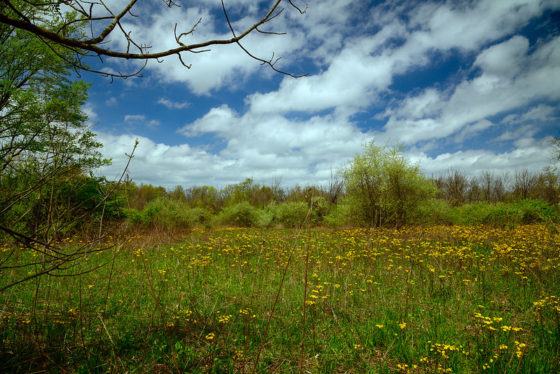
The early afternoon sun illuminated the light green buds and yellow flowers in the meadow, against an interesting sky. The yellow spring flowers dotting the meadow are Groundsel or sometimes called Ragwort.  The forecast called from clouds and possible rain, but we experienced some beautiful sunny periods when it counted. 

For a small and quite remote trail, the Pinhook Bog Upland trail was filled with quite a bit of activity. Aside from the families hiking, quite a few individuals were hiking with hand held baskets- it is Morel mushroom season, and my guess is they're out to find mushrooms in the beech forest. I asked one person carrying an Easter basket if she had any luck finding mushrooms, she replied, "I'm just out for a nice walk." Mmm hmm, a nice walk holding an Easter basket. Of course, picking mushrooms at the national park is illegal, so what else could she have said?

Totality


Totality

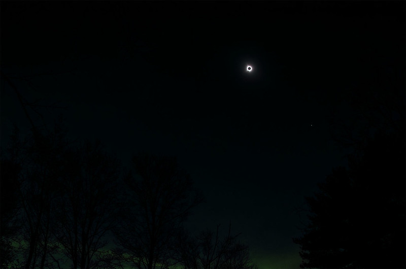
Totality seemed to happen in a second, even the 1% of sunlight was enough to illuminate the environment - dim and oddly colored, but still bright. Once totality took place, everyone removed their eclipse glasses and enjoyed the view. I concentrated on bracketing the sun's corona, taking numerous photos at different exposures to capture the different elements of the phenomenon. 

We only had four minutes to view, adjust, adapt, and capture images, but I also wanted to take in the experience with my eye out of the viewfinder. In addition, I wanted to capture the environment around me during totality, so I brought along an older camera to do just that, without the need to change lenses and settings on my Z8. Attempting to match the light as I experienced it, is not as easy as it seems. Shooting manual exposure, I can adjust the camera to take a photo during the eclipse that would be as bright as a normal day, so I kept the settings the same as the images I captured around the yard prior to totality. That, I think, gives a correct impression of just how dark things were. 

It's amazing how small the sun appears when it's covered by the moon- all that radiation spreads out and tricks our eyes and makes it appear huge. It's really about the size of the full moon, and that's a very interesting coincidence for those of us on earth. If the moon was smaller, or the sun was closer, we would never had a total eclipse, the moon would transit across the sun and that's about it. If the moon was larger, we would have an eclipse, but the sun's corona would be obscured during most of the event. So, we're quite lucky to have these bodies as they are, so during syzygy (the alignment of the earth, moon, and sun), the moon covers the sun almost perfectly, and the moon creates the dark shadow on the earth called the umbra. 

It's a shame eclipses don't last longer, and they don't happen more often. I suppose if they did, we'd take them for granted instead of traveling hours to gaze at them in awe.

The Dune Ridge Trail in Spring


The Great Marsh 
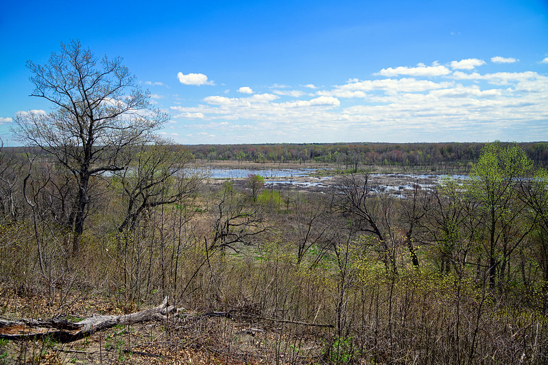
Things are waking up quickly around the Indiana Dunes National Park. Taking a quick hike up the short Dune Ridge Trail near Kemil Beach revealed quite a bit of "greening up" along the dune and especially down in the Great Marsh. The Great Marsh is a wetland running parallel to the Lake Michigan shore, on the leeward side of the aft dunes. This 15 mile long by 1/4 mile wide wetland was once all marsh, but since the 1900's, it's been drained in spots for houses, farmland, and industry.
 
Restoration of this wetland began back in the 1990s, and evidence of this still exists with thousands of tree stumps in the water. The trees were killed either by girdling (cutting around the circumference of the trunk) or by flooding after drains were removed. Either way, more and more of the Great Marsh is being restored every year. 

A road once cut through a good portion of this marsh, but flooding ruined it, and the park closed the road about 8 years ago. This road is now part of a new trail system that takes visitors between the aft dune and the edge of the marsh. The road can be seen in the distance in the photo above.
  Lined With Lupine 
The relatively short and simple trail up the dune is called the Dune Ridge Trail, and at this early time of the year, I was surprised to see lupine blooming. I expected them to bloom a few weeks from now, but with the warmer weather, and the sun heating the sand, they're all ready to go. Soon, the Tolleston Dune Trail will have areas of lupine seemingly acres wide, running along the trails, into the woods, and up the dunes. It's a beautiful thing to see. 

Later in the early summer, the prickly pear cacti will bloom as well. Now is a great time to get out to these trails to see what is blooming this week. It's interesting to see how things change so quickly in the spring, and even more interesting to see how these areas change with each season, with each month, and even with each week.

The Phases of the 2024 Total Eclipse

Total Eclipse Phases 
The many phases of the eclipse in a composite of 19 images taken from first contact through last contact. Looking at the timeline below, you can see there are only about 5 seconds between some events, such as the diamond ring and Baily's beads, and totality, so there's little time to react and change camera settings.

The timeline of the eclipse:

01:50:22   The edge of the moon begins to block a portion of the sun 
02:13   20% obscuration 
02:20   Temperatures begin to change 
02:35   The sky begins to darken 
03:05:33   The corona appears 
03:05:43   Diamond ring 
03:05:48   Baily's beads 
03:05:53   Totality begins 
03:09:55   Totality ends 
03:09:56   Baily's beads 
03:10:00   Diamond ring 
03:32   Temperatures return to normal 
04:01   20% obscuration 
04:23:13   Eclipse ends

Solar Prominences

Solar Prominence Detail

So many events happen during the brief solar eclipse, it's almost impossible to experience them all, and even more difficult to photograph them all. Camera settings and equipment can be very different for each phase, and some phases only last a matter of seconds. In the case of the sun's chromosphere, this took place at 3:05 and 54 seconds, and ended at 3:05 and 55 seconds - yes, one second! One second to assess, adjust, and execute. Well, I may or may not have captured this one second event, but in this photo, solar prominences are visible along with the bright red color of burning hydrogen.

These prominences are loops of hydrogen plasma from the sun's surface up into it's atmosphere, and these are actually larger than the earth, extending hundreds of thousands of miles away from the surface. According to the Holcolm Observatory, the one in the top photo measures three times the diameter of earth!

Generally, one needs to use special equipment to see these effects, often including a hydrogen-alpha filter that captures the wavelength of light these give off. Hydrogen-alpha filters are very expensive (I wanted to use one for the eclipse phases until I priced them), so I waited for nature to do the work for me. During totality and a few moments prior and after, solar prominences are visible without the aid of special filters. There was plenty of activity on April 8, 2024, so the eclipse did not disappoint. 

Following totality, a large prominence was visible near the south pole of the sun. Looking a lot like a tongue of fire, the plasma loop stood out against the black surface of the moon, and the blackness of space. 
  First Solar Prominences 
Here, Baily's beads were just finishing up, and a bit of the sun's chromosphere is visible - the thin, bright red outline around the moon.
Once again, photography has persuaded me perform a deep-dive into a subject to find out more and more about the things I've seen behind the camera.

The Corona and the Chromosphere

Moon Surface Visible with the Sun's Corona 
In an attempt to pull any amount of detail from the dark moon, and bring out as much of the captured corona as possible, the image above resulted. A very small bit of detail can be seen of the moon's surface, lots of grain, but it's there. The sun's chromosphere can be seen at the bottom of the moon, reflecting red off of the surface - that's the hydrogen burning. This phenomenon is only visible for about five seconds at the very end of totality, right before Baily's beads.

This image was created using the 10 image stack from the previous post, and a new one with the chromosphere. This 11 image stack shows just how far the corona extends. According to NASA, the corona extends five million miles above the sun's surface. That's over five times the diameter of the sun.

The Sun's Corona and Diamond Ring


The Sun's Corona During Totality 
I spent a few days in suburban Indianapolis, Indiana to make certain I would be around to view the total eclipse of 2024. Back in 2017, I was working, and didn't make the trip south for that particular eclipse, and vowed I would not miss this one. 

Almost a year ago, I began planning, and several months ago, I put in for vacation to make sure there was nothing keeping me from seeing this event - except perhaps the weather. Hearing how horrible the traffic could be, I decided to head down a few days early, and stay at least another day. I did luck out in the traffic department, while everyone else was sitting in traffic heading northbound on I-65, I was either relaxing in my nephew's yard, or on Tuesday, driving down some farm roads west and north - I suppose these roads weren't GPS detours for traffic because they were almost empty. I-65 was backed up in several places throughout the day, and I'd probably still be sitting in traffic if I took that route. 

The weather forecast for two weeks mentioned cloud cover, and even on the morning of the eclipse, there was a 25% cloud cover forecast - while I looked up and saw very few clouds if any. We lucked out and had a relatively clear sky, with some very high, light haze which did mess a bit with the bright tones on the photos, but it didn't destroy them. 

I met some family and some friends - old and new - for the event, right in my nephew's large back yard. His BBQ dinner was excellent by the way. We all set up and waited for syzygy - the alignment of earth, the moon, and the sun. All the while taking photos of the different phases of the eclipse using a Baader filter on my 600mm lens (any closer and the corona will be cut off). Even this part of the event was excellent - and I've seen a few partial eclipses, but once the moon covered the sun, the fast darkness took hold and it was spectacular.

I planned on bracketing several exposures during totality, to obtain the best range of exposures of the rays of the sun's corona. I used 10 separate images for the photograph above, all aligned and stacked together to form an average of exposures to create one image showing the extent of the corona. 

The image shared in the previous post was done from one image, and on an older laptop, so I was not happy with it at all once I saw it on a decent computer monitor. This one seems a bit better - if not, let me know!
  The 2024 Eclipse Diamond Ring 
 Just before totality - at 3:05 and 43 seconds, the diamond ring effect took place. This is when only a small bit of the sun peeks over the moon, creating a relatively small point of light, along with some light from the corona around the moon - this looks a lot like a ring, and the bright spot on top, looks like a diamond. This lasted for 4 seconds until the sun was all but covered completely. There isn't a lot of time to remove the Baader filter and re-adjust the camera, but I managed to get things done in time - a camera capable of taking 120 images a second really helps. 

I like this diamond ring image better than yesterday's as well. If you look around the top of the image, you can see lots of solar prominences - huge, bright plasma looping from the sun's surface into the sun's outer atmosphere.  These colorful, hydrogen formations are huge, sometimes larger than several earths combined - the largest on record was about to 500,000 miles across.  

When is the next eclipse? 2026 in Iceland I think. I'll start making plans now.