
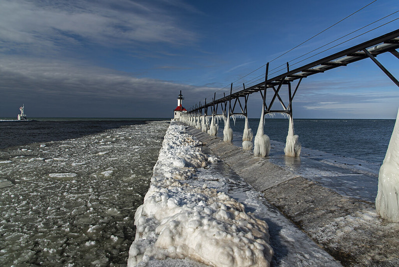
 What was a bright, sunny day as we arrived at the St. Joseph, Michigan lighthouse, turned to an overcast winter day quite quickly, and dramatically. In fact, the fleeting transition between sun and clouds lasted only a moment or two.
An overcast day generally provides very flat light, no real bright spots, no dramatic shadows. Compare that to a sunny day where the dynamic range in light is extreme from sun to shadow. When the clouds rolled in, they blocked most of the sun quickly, but the last few rays of sun illuminated the ice against the dark clouds and water. This created a dramatic, haunting look and feel to this image.
What was a bright, sunny day as we arrived at the St. Joseph, Michigan lighthouse, turned to an overcast winter day quite quickly, and dramatically. In fact, the fleeting transition between sun and clouds lasted only a moment or two.
An overcast day generally provides very flat light, no real bright spots, no dramatic shadows. Compare that to a sunny day where the dynamic range in light is extreme from sun to shadow. When the clouds rolled in, they blocked most of the sun quickly, but the last few rays of sun illuminated the ice against the dark clouds and water. This created a dramatic, haunting look and feel to this image.
Haunting Ice
What was a bright, sunny day as we arrived at the St. Joseph, Michigan lighthouse, turned to an overcast winter day quite quickly, and dramatically. In fact, the fleeting transition between sun and clouds lasted only a moment or two.
An overcast day generally provides very flat light, no real bright spots, no dramatic shadows. Compare that to a sunny day where the dynamic range in light is extreme from sun to shadow. When the clouds rolled in, they blocked most of the sun quickly, but the last few rays of sun illuminated the ice against the dark clouds and water. This created a dramatic, haunting look and feel to this image.
Ice Around the Pier
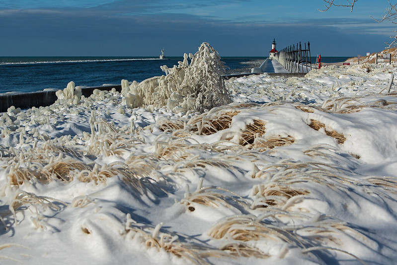
Early winter creates some sculpted ice on the shore of Lake Michigan where the water splashed up on every nearby surface and froze. Every blade of grass, every branch, and every railing is covered in a thick coat of ice.
I arrived expecting much more ice on the lighthouse itself, but there is very little compared to most years - at least so far. There was quite a bit on the pier and the plants close to the river, where the waves push up and overflow the banks.
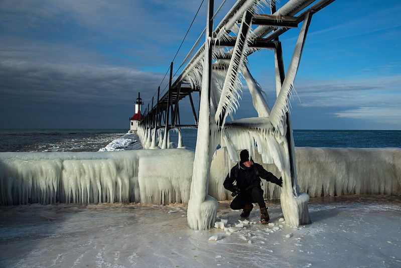
On arrival, it was clear with full sun, but after a few minutes the clouds rolled in, changing the look of everything very quickly. The long icicles hanging from the catwalk were still illuminated by the sun, and stood out against the darker sky. The transition between sun and clouds can be seen in the image above.
That cloud mass brought with it some freezing rain which covered the roadways with a thin sheet of ice. Our one day trip turned into two as we decided to stay the night instead of attempting the drive all the way home.
The "Hoodoos" of St. Joseph Michigan

Like miniature versions of the sandstone formations of the Badlands and Brice Canyon, Utah, these formations look a lot like "Hoodoos." These particular formations, however, are only temporary features of the Lake Michigan shore.
Winter does some incredible things to the beaches along the shore of the Great Lakes, but in addition to the ice and snow, small details often get overlooked. When water falls on sand, it seeps down to the layers below; in cold weather, the water turns to ice. Along the beaches, winds hit the shore and slowly move sand away from the lake, but the frozen portions don't wear away, they remain. These remaining formations are incredible little sculptures I call Hoodoos.
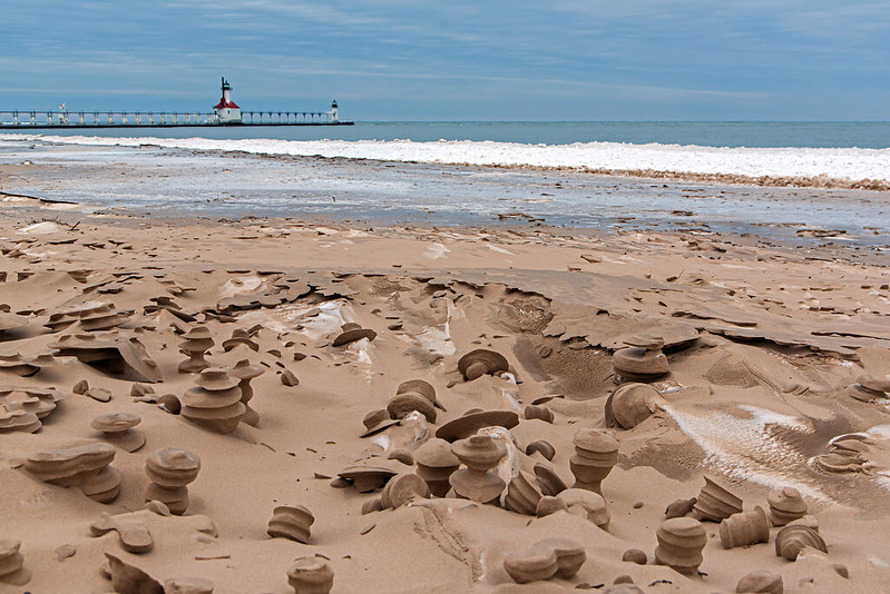
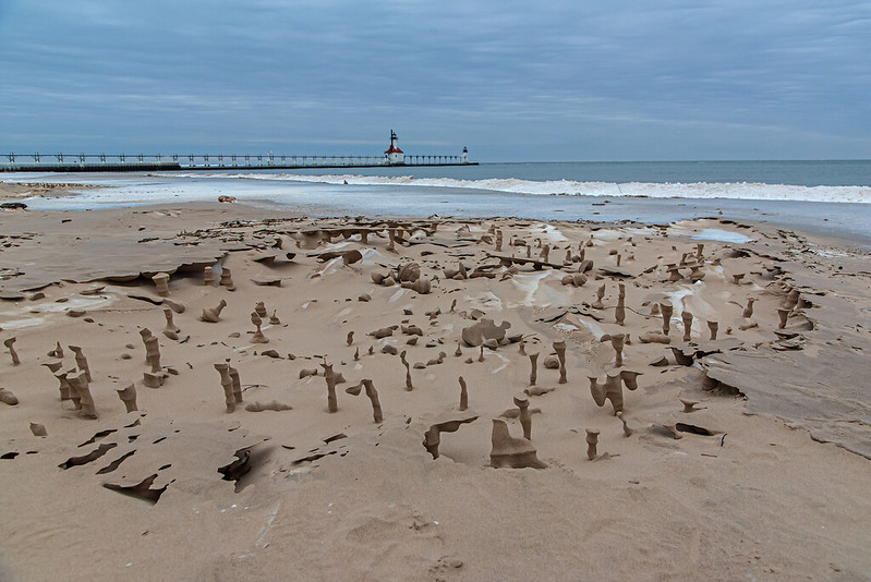
I've seen these formations for years in other places. Usually, they are formed when wind mixes the snow with sand, and the snow begins to melt, then freezes again. I found hundreds of these in Silver Lake, Michigan in 2017, and blogged about them in my Huffington Post blog: Click here to view that post. The ones in St. Joseph, Michigan this year are much smaller, and confined to a rather small section of the beach, but they are a bit more consistent in style.
I was surprised to see quite a few kids and families were exploring the Hoodoos in the bitter cold wind. In years past, I was often the only person on the beach in the winter; it's good to see people getting out to explore and come across things they never imagined, like the interesting Hoodoos of St. Joseph, Michigan.
The Ice is Beginning to Form
The new year brought some frigid weather to the southern Lake Michigan area, enough to begin the creation of some thick ice on the pier and catwalk of the St. Joseph, Michigan lighthouse. Typically, the ice begins to form much earlier in the season - sometimes in late November - but this winter, conditions weren't right until now.
Conditions include very cold temperatures, winds high enough to churn up waves that crash into the pier and lighthouse, and a liquid lake (not frozen yet) so waves can build up. A layer of ice on the lake prevents the water from splashing up, so later in the winter when the lake usually freezes over, ice rarely builds on the lighthouses.

While the ice hasn't yet covered the lighthouse, it is beginning to freeze the surfaces of the pier, railings, and catwalk. The ice on the railings is already about two feet thick may continue to build depending on how conditions are in the future.
Many years ago, winters along the Lake Michigan shoreline were generally lonely, very few people ventured to view the lighthouses or ice along the shore. In recent years, however, crowds of people brave the cold weather to experience the ice formations. As long as the everyone keeps off the ice, it's a great thing to see.
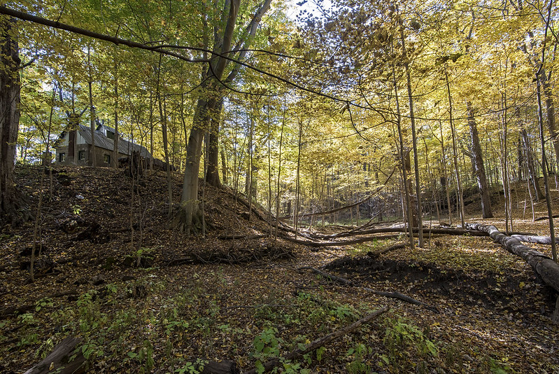
Autumn Hike on the Boardwalk
 This Fall season was relatively warm and dry, so the thought was that the leaves would drop early and without much color. As it turns out, the color was great, it was just delayed a few weeks. Visiting the Chellberg Farm trails at the Indiana Dunes National Park has become a tradition in the Fall, and it never disappoints. This area has scores of maple and beech trees that turn golden in autumn, and the rolling landscape provides the perfect setting for a hike.
Boardwalks and stairs provide relatively easy access through the deep gullys of this area. Even in the rain, hikers can enjoy the landscape without too much mud or overflow of streams.
This Fall season was relatively warm and dry, so the thought was that the leaves would drop early and without much color. As it turns out, the color was great, it was just delayed a few weeks. Visiting the Chellberg Farm trails at the Indiana Dunes National Park has become a tradition in the Fall, and it never disappoints. This area has scores of maple and beech trees that turn golden in autumn, and the rolling landscape provides the perfect setting for a hike.
Boardwalks and stairs provide relatively easy access through the deep gullys of this area. Even in the rain, hikers can enjoy the landscape without too much mud or overflow of streams.
 On the day of this hike the parking area was overflowing with cars, and the remote lot was being used. Surprisingly, these trails were almost empty; I wonder if visiters only knew about the short trail near the sugar shack and behind the farmhouse. Venturing past the barns and field, one finds the trail that wanders through these rolling, wooded dunes. There are a few trails that total about four miles (maybe more if you wander off toward other parts of the park), but this trail is about a mile loop. It's well worth exploring any time of year, but especially in the Fall.
Autumn Gold
Walking through the sugar bush in autumn is amazing. The sugar bush is another term for a wooded area filled with maple trees used for maple sugar, and maple trees are known for their beautiful Fall color. One of my favorite places to explore in autumn is this particular sugar bush at the Chelberg Farm in northwest Indiana. The farm is part of the Indiana Dunes National Park, and a huge contrast to the beaches and lakeshore most people think of when they hear about the dunes.
These hills are dunes, long ago deposited by the wind and waves of a then much larger Lake Michigan. Over time, the grasses gave way to trees and the falling leaves helped create a more fertile soil to support more types of trees. The trees in this area were most likely planted by the early farming people like the Chelbergs to produce maple syrup.
The sugar shack can be seen at the top left of the image. This is where the maple sap was boiled until a good portion of the water evaporated, creating maple syrup. Tours of the sugar shack are given every March during the prime sap collection time.
 Hiking the winding, hilly trails of the sugar bush is absolutely beautiful in the Fall. This area has to be the most colorful of the entire park, and certainly worth the visit.
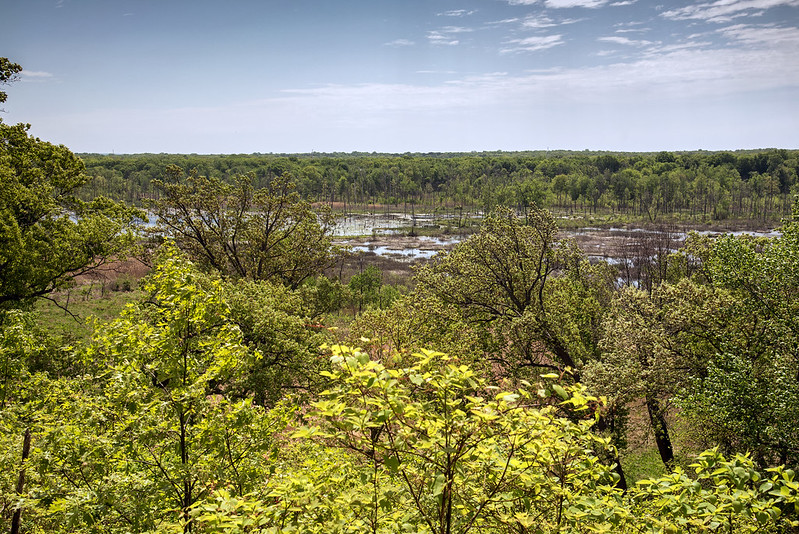
The Great Marsh

There is plenty more to the Indiana Dunes National Park than dunes and Lake Michigan. The largest interdunal watershed in the Lake Michigan area is located here. Called the Great Marsh, this area was once drained to make way for homes and agriculture. In 1998, this area was restored by the park service back to it's original state of a wetland.
Visiting the park for many years, I have noticed the trees in the marsh have all but disappeared. Not knowing the story of the area, I figured the wetlands were drained many years ago, and more recently, the area was left to come back to being a marsh. The area flooded again, and the trees that were once growing in dry soil, have since died and are slowly decaying into the swampy area.
From the dune ridge trail at Kemil Beach, a portion of the marsh can be seen. I've hiked this trail numerous time and always wanted to walk through the marsh below. For some reason, I failed to realize that the closed portion of Beverly Drive passed through this exact area - it was not easily seen from above. When I realized this, I immediately walked down to the road and followed it through the wetland.
The road has been closed for at least five years, and in that time nature has begun to reclaim the surface. It makes a great trail for people walking, running, and biking, even though it's not a natural trail. There are a few small channels under the road that connect the two sides of the interdunal wetland, and small wood bridges spanning them to make them passable.

I'm not certain what will become of this road - will the park make it a designated trail, or attempt to keep people away from it? For now, it seems to be a popular trail for locals who know the area, and the in's and out's of the old road system.
Developing Storms
 While kayaking at sunset, we watched two storms develop in the distance. The first was to the south, and the whispy clouds caught our attention at first. They soon developed into billowing clouds highlighted by the setting sun. After the sun sank below the horizon, the lake and trees darkened, but the storm clouds remained vibrant for quite some time. Lightning could be seen between the clouds, but the storm never came any closer to us.
This image was made with four individual photos stitched together side by side. I only had a 100mm lens with me, so a panoramic image was necessary to capture the entire cloud.
While kayaking at sunset, we watched two storms develop in the distance. The first was to the south, and the whispy clouds caught our attention at first. They soon developed into billowing clouds highlighted by the setting sun. After the sun sank below the horizon, the lake and trees darkened, but the storm clouds remained vibrant for quite some time. Lightning could be seen between the clouds, but the storm never came any closer to us.
This image was made with four individual photos stitched together side by side. I only had a 100mm lens with me, so a panoramic image was necessary to capture the entire cloud.
 At the very same time, to the east was an even larger storm developing. Again it was highlighted by the setting sun and never approached us, we remained dry the entire weekend. This panoramic image was created with eight separate images taken with a 100mm lens while sitting in a kayak on the lake.
Paddling any time during the day is great, but paddling at sunset and after dark is especially interesting. Our 11pm trips are always inspiring.
At the very same time, to the east was an even larger storm developing. Again it was highlighted by the setting sun and never approached us, we remained dry the entire weekend. This panoramic image was created with eight separate images taken with a 100mm lens while sitting in a kayak on the lake.
Paddling any time during the day is great, but paddling at sunset and after dark is especially interesting. Our 11pm trips are always inspiring.
Superior Mirage

While hiking on some dunes near the shore of Lake Michigan, I captured the Michigan City East Pierhead lighthouse from the Central Beach area, a bit more than 2 miles away. The land on the horizon to the left of the lighthouse is over 30 miles in the distance, and generally cannot be seen from this vantage point. Thanks to Google Earth, I determined the land in the center of the image is actually north of Bridgeman, Michigan!
When conditions are perfect, a superior mirage forms, making the land past the curvature of the earth visible, but upside-down. While this mirage was not as perfect as I've seen them, a portion of the land closest to the water is upside-down. In the past, I've seen the entire object in the distance upside-down - including all of the buildings in the Chicago skyline.
Because of the optics of a superior mirage, objects that are normally past our view can be seen hovering over the water, forcing plenty of double-takes by visitors to the beach.
Fiddleheads

Each Spring, I look forward to visiting the woods, the prairie, and the wetlands to watch life "wake up." One of the more interesting things for me to find are fern fiddleheads. Late April and early May are the best time to view them as they are all opening up at the same time, and they often fill the shaded areas of the wetlands.
Generally, Cowles Bog is a great spot to find ferns, right at the end of the boardwalk through the wetland. This is the spot I generally pick in the early spring. This year, I decided to check out the dune ridge trail, near Kemil Beach. I remember plenty of skunk cabbage and ferns located in a small area next to the trail adjacent to the wetland. Sure enough, there were plenty of ferns emerging.
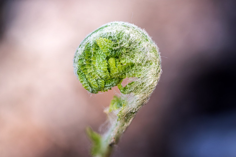
The evening sunlight filtered through the budding trees and illuminated the fiddleheads at a low angle, and sometimes from behind. There are so many stages of unrolling, from a disk of white hairs to seeing the first small fronds curled up inside the tightly wrapped spiral. They're always facinating to me. Soon, these fiddleheads will become 18 inch long fern fronds that cover the wetland floor.
The Waxing Crescent

I'm working out all of the alignments and adjustments on the tracker now, so when the new moon arrives in a few weeks, I will be all set for some deep space photos. So far, using a 100mm lens, I've been successful in capturing clear star images up to three minutes in length. These longer exposures really help capture the dim light on the stars and nebula with very low noise or grain, so I can't wait for clear, dark summer nights.
For the moon image, I used an 35mm film equivalent of a 1800mm lens and managed this capture hand-held - the moon is actually very bright in the night sky.
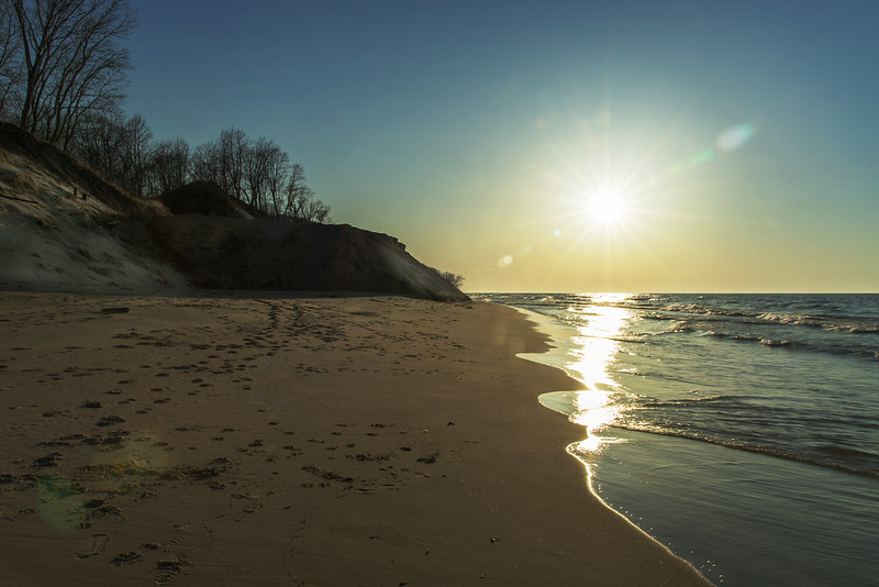
Colorful Lake Michigan
 Certain mornings play with Lake Michigan's colors, and this was certainly one of those mornings. As we approached the end of the trail, which was once a road leading to homes and a beach access, we stood at the edge of the dune that overlooked the beach below. The dune is around 100 feet tall here, but with no people on the beach for reference, it looks as if I am standing on the beach itself.
The clouds cast shadows on the water, changing the color of the waters, and in addition, the sand is kicked up and circulated in the water, creating some deeper brown colors along the shore. While this coloration is not really unusual, it changes from moment to moment and often can't be seen from the beach itself.
Certain mornings play with Lake Michigan's colors, and this was certainly one of those mornings. As we approached the end of the trail, which was once a road leading to homes and a beach access, we stood at the edge of the dune that overlooked the beach below. The dune is around 100 feet tall here, but with no people on the beach for reference, it looks as if I am standing on the beach itself.
The clouds cast shadows on the water, changing the color of the waters, and in addition, the sand is kicked up and circulated in the water, creating some deeper brown colors along the shore. While this coloration is not really unusual, it changes from moment to moment and often can't be seen from the beach itself.
 Following what was once California Avenue, we found the end of the road - which led right off the dune to the beach below. I remember walking this road and Valley Drive when there were still homes on them. And often, after the homes were razed, we would follow a path along the top of the dunes right at the lakefront. This path has since been washed into Lake Michigan - but not because people walked on it as the park service would seem to want you to believe. People do much less damage to the dunes when they follow a path or trail than they do if you block off the traditonal paths. Some will simply walk around the sign or barricade, creating more damage as they walk around. Lake Michigan eroded the dunes here, not people walking on the dunes.
Last Sunset of Winter
Generally, we visit the beach in the mornings and view the rising or low morning sun, but on the last day of winter, we stopped off in the evening. What's most unusual is the lighting, it's coming from the opposite direction; we're used to seeing it on the other side of the dunes!
The last day of winter 2021 was relatively warm, and followed a couple of days of high winds. A little beach erosion was evident as we hiked to Kintzele Ditch, some full sized trees have fallen to the beach from the top of the dunes as they were undermined by waves. In the background, you can see the large pile of sand that was delivered to the beach last Fall, it is slowly breaking down as well. The intent for that is to be spread a bit along the shore this Spring, so the waves are helping with that.
It was nice to see people enjoying the beach again, although there were only a few, with the sun and the warmer temperatures, things are certainly looking up. Not only does it feel like Spring, now it is Spring!
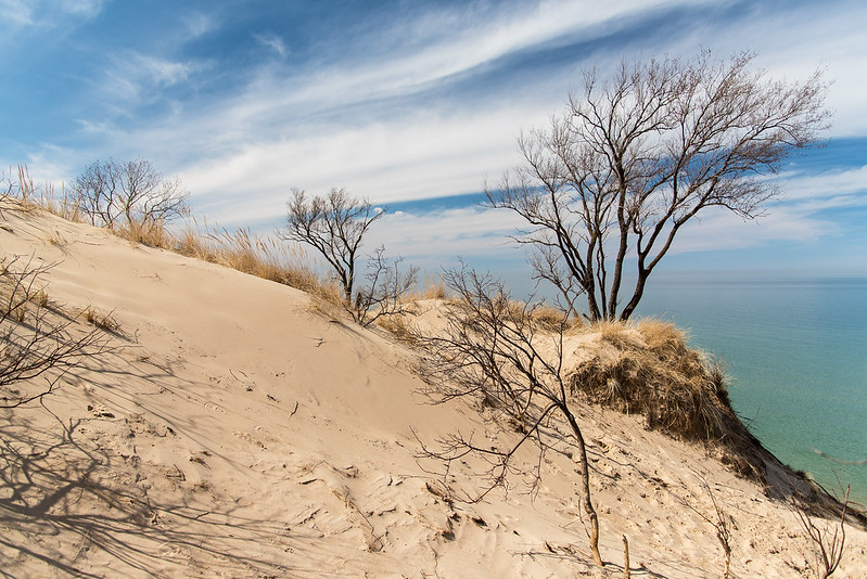
The Dormant Dunes
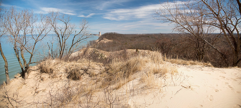
In late winter, the plant life on the dunes is still dormant and brown, waiting for a few more days of warm weather and rain to kickstart the spring green-up. Even in this dormant state, the woods and grasses are inviting, and from this elevation, they seem to go on forever. I can imagine hiking down these dunes through the woods and clearings, and walking for miles. Unfortunately, that's not allowed here, and much of the wooded areas around the park are private property.
It's amazing how calm and peaceful it is when you stop and look around. A large city is just up the shore, and other smaller residential areas surround the dunes on three sides, but aside from the occasional train horn and air plane, nature is all you hear. When Lake Michigan is churning, only the waves can be heard, but on this morning, it was only birds and the squeaking of the sand beneath our feet.

Turning and looking in the opposite direction, more dunes and woods can be taken in. The views from this dune are quite expansive, and seem to go on and on. Tucked away between the dense bare trees are some homes in the distance, those of nearby towns such as Pines, Dune Acres, and Beverly Shores. They're all within walking distance of Lake Michigan and in such a picturesque, rolling dune setting. So close to the National Park, and also so close to the once booming steel industry of Northern Indiana. That industry is waning, and what remains is mostly hidden from the view of the homes by the dunes and the woods.
Morning on Top of the Dune
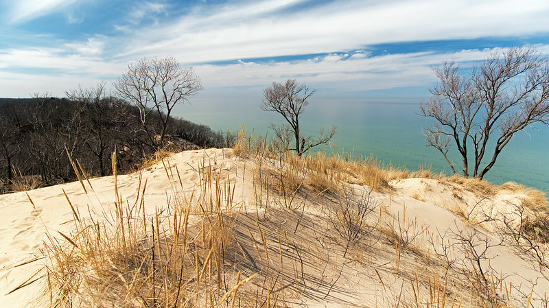
It's almost spring - and it certainly felt like it at the lakefront. Weather forecasts were calling for high temperatures in the low 40s, but even early in the day, the warmth from the sun drove temps into the 50s. Couple that with a rather strenuous hike up the sandy dunes, and jackets are optional.
The bright sunlight illuminated the dunes, and made the short layer of fog in the distance blend in with the horizon.
Looking at the horizon, a superior mirage was evident in a few spots over Lake Michigan. This type of mirage stretches the objects on the horizon vertically, and sometimes turns them upside down! Objects normally not seen because of the curvature of the earth can be seen hovering above the water upside down. On this day, we didn't see anything so dramatic, but some areas of sand in the distance were stretched into what appeared to be buildings on the horizon.
It's interesting to see just how fast the sand dunes warm up in March. The sand is very warm to the touch just two weeks after being frozen solid. We looked around and found a few small footprints in the sand, most likely from some type of insect. We also encountered a snake warming itself in the sun. Life is once again beginning to return to the dunes - and that includes people, we ran into quite a few along the beach.
The Thawing Ice Falls

On what we knew would be our last visit to the frozen waterfalls of Matthiessen State Park, we were lucky enough to find the two waterfalls in this canyon still frozen. The other more popular and easier to access waterfalls were no longer frozen, so these were exciting to find still somewhat frozen. While not quite complete, and missing the intricate ice patterns that form when the weather is very cold, they remained interesting to explore.
Generally, we could climb behind the ice and enter the caves formed by the ice, but with the warm temperatures and melting ice, it was very wet, and a little hazardous if a huge chunk of ice decided to break loose and fall. While the ice looks a bit undefined and dirty as it melts, the running water provides a fun challenge to capture - especially when you leave your tripod behind and need to attempt a slow shutter photograph holding the camera.
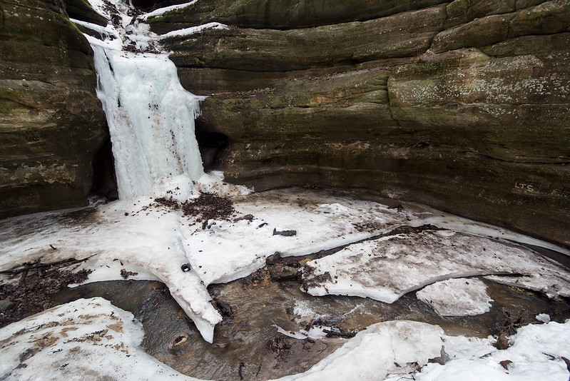
This waterfall is one where we usually explore the cavity behind the ice, and it's tall enough to stand up inside, and about 12 feet tall to the first major cascade on the rockface. We did head inside but were immediately soaked with water dripping from above. We were already soaked to the knees from crossing the swollen stream at the head of the canyon, we didn't need to get our gear wet as well.
After crossing the stream, we had a narrow strip of ice to walk along to reach the waterfalls. This is often a shallow creek in the warm months, so generally only about 3 inches of our boots get wet, and in this area, only the soles. Mud is usually the normal in this section, so the remaining ice was a welcome sight, almost like a white carpet leading us to the frozen falls.
Approaching the Dual Waterfalls

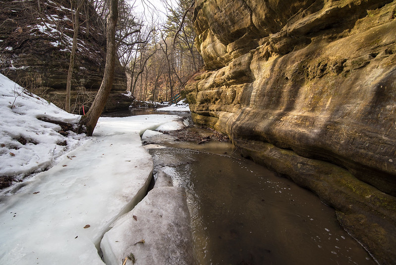
We hoped to see at least one frozen waterfall on our trip to Matthiessen State Park, in northern Illinois. Unseasonably high temperatures would surely melt the icefalls, and as we hiked past the lower dell overlook, we could hear a lot of water flowing over Cascade Falls below us. Certain all of the waterfalls were gone, we made the hike across the swollen stream to the small canyon past Cedar Point. This canyon typically has two waterfalls, and in winter, they freeze to form ice caves.
As we made the first turn in the canyon, we could see the first fall was indeed still frozen. With some melt occurring, some of the intricate details were missing from the ice formations, and a lot of leaf debris could be seen in the ice and the snow on the canyon floor.

The meltwater from the snow in the park was flowing over the icefalls, making it a bit difficult to access the falls, but more difficult to get behind them and into the ice caves. Careful not to walk under any of the hanging ice - for fear it would fall and crush us - we did manage to get inside the ice caves which were pouring with water.
Because we had to walk through knee-deep water in the stream to access these waterfalls, we shared the canyon with only one other visitor. Surprisingly, walking through the cold water wasn't so bad, the water in your boots warms up a bit after a few minutes.
Lake Falls

A full wall of ice just days earlier, Lake Falls is flowing once again thanks to the large amount of meltwater flowing into the lake above the falls. Hiking through Illinois' Matthiessen State Park during winter yields quite a few frozen waterfalls -at least six. On this visit, they were in various stages of melting, some completely gone, and others, half way thawed. The melting increased the amount of water in the upper and lower dells, which in turn, destroyed more of the icefalls.
Not only is the ice melting, but to get to the frozen waterfalls is much more difficult if you wish to stay warm and dry. The paths for at least two of these falls were under at least a foot of flowing water. We decided to visit them anyway, and walked through the cold water; our feet were cold for about 10 minutes as the 35 degree water flooded our boots. But after that, they remained a rather comfortable temperature as our body heat warmed up the water in our boots. Even if our feet stayed cold, it was worth the effort to see these falls once again.
Not only is the ice melting, but to get to the frozen waterfalls is much more difficult if you wish to stay warm and dry. The paths for at least two of these falls were under at least a foot of flowing water. We decided to visit them anyway, and walked through the cold water; our feet were cold for about 10 minutes as the 35 degree water flooded our boots. But after that, they remained a rather comfortable temperature as our body heat warmed up the water in our boots. Even if our feet stayed cold, it was worth the effort to see these falls once again.
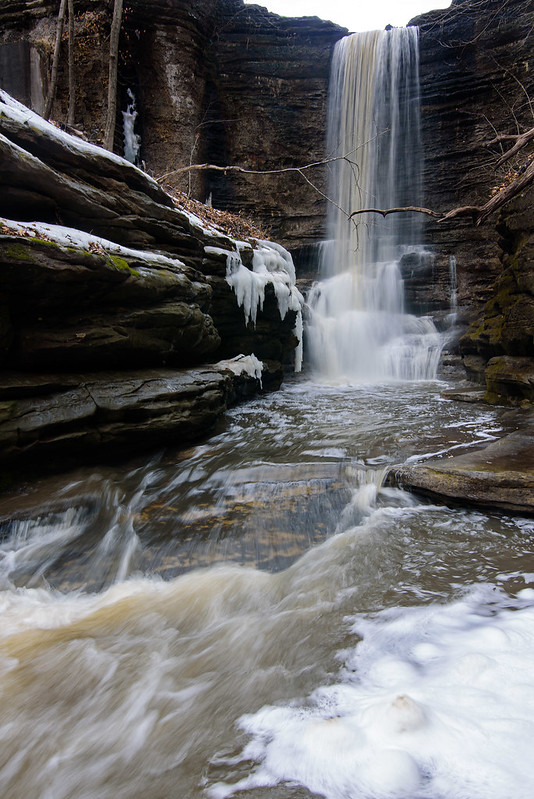
Generally Lake Falls is a bit more accessible, and flows a bit more gentle, but this time we couldn't get too close to the falls without getting ourselves and our gear sprayed with water. Many of the interesting logs that fell into the canyon have disappeared over the years; these were often covered in intricate ice formations, but no longer. The stream is filled with small cascades of water most only a foot tall like the one in the foreground of the top image. These provide great elements in the landscape, and give so many possible compositions.
I hiked this time without my tripod, so these images, which were taken with a slow shutter of 1/6th of a second, were taken handheld with no support. Without a tripod, it gets a bit tricky to get sharp images at that speed.
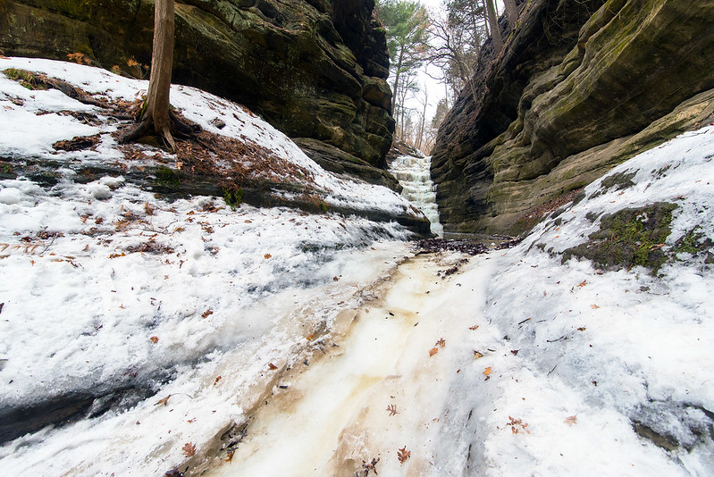
Frozen French Canyon

Following a week of warm weather, we decided to visit Starved Rock State Park once again, before all of the frozen waterfalls were melted. On our last trip in the very cold weather, we visited the waterfalls that generally have the most intricate ice formations - knowing they would soon be gone. On this hike, we saw the melting icefalls that we figured would still be somewhat frozen, and we were right.
These waterfalls tend to stay frozen for a bit longer than the fragile falls in LaSalle Canyon because they're thicker and in more shaded canyons. French Canyon is one of those very shady locations and generally doesn't have a huge amount of water flowing into the canyon. A heavy flow of water quickly melts the ice formations, while a more gentle one cascades over, under, or around the ice.
These waterfalls tend to stay frozen for a bit longer than the fragile falls in LaSalle Canyon because they're thicker and in more shaded canyons. French Canyon is one of those very shady locations and generally doesn't have a huge amount of water flowing into the canyon. A heavy flow of water quickly melts the ice formations, while a more gentle one cascades over, under, or around the ice.
This canyon is generally a bit tricky to access when the stream is flowing (if you don't want wet feet), but in winter, it's extremely slippery and difficult to access. Park staff at the visitor's center have told us time and time again that it's not worth even trying to get into French Canyon in the winter - it's too dangerous. The stream flows directly on the portion of the canyon floor that is used for walking, so plenty of ice forms in this area. Without ice cleats on your boots, it's next to impossible to safely walk up into this canyon. Because we've been here many times before, we had our cleats with us.
In the photo above, you can see just how frozen the canyon floor was. No place to hold on to, so you absolutely need ice cleats, and even then, if there is snow on top of the ice, or if the cleats hit rock, you will still slide. I would hate to fall here, not only would you get wet, but you would probably continue sliding 30 or 40 feet down into the pool of water at the entrance to the canyon. I don't know how deep that water is, but you would certainly have a difficult time climbing out, and a very cold walk back to the car.
The recent high temperatures has created quite a bit of melt water, in fact, it flooded the canyon and kept us from walking too far in. We were already wet to the knees from walking through the stream at Matthiessen Park, but we weren't too certain how deep this water was, so it was best to keep out of the flooded canyon.
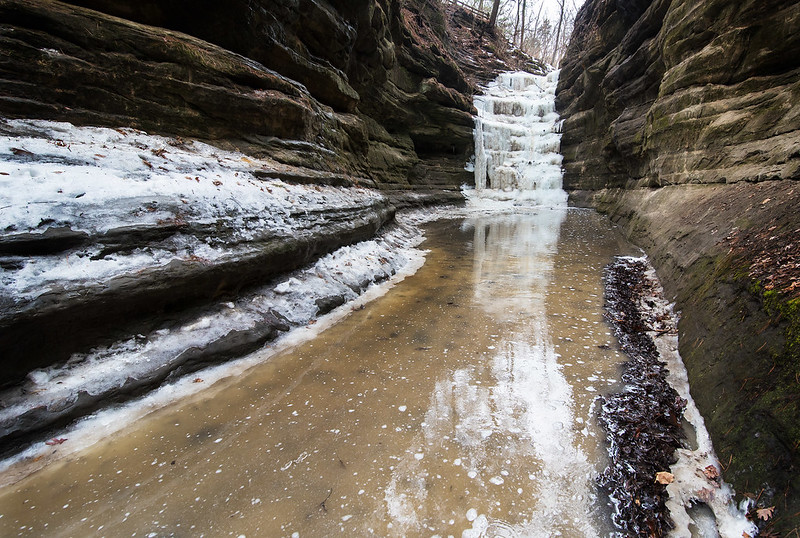
The melt water did allow for some very interesting colors and a nice reflection of the 40 foot tall frozen waterfall. This waterfall doesn't freefall into the canyon, it cascades over the stepped rock formations, so I think it's one of the more interesting waterfalls of the park.
Every day the warm weather eats away at the ice in all 18 canyons of Starved Rock, so if you hope to see some frozen waterfalls, it's best to visit very soon, or you will need to wait until next winter. Bring ice cleats even if you think the trails are clear - you will need them - sometimes into April.
Every day the warm weather eats away at the ice in all 18 canyons of Starved Rock, so if you hope to see some frozen waterfalls, it's best to visit very soon, or you will need to wait until next winter. Bring ice cleats even if you think the trails are clear - you will need them - sometimes into April.
The Thawing Shelf Ice
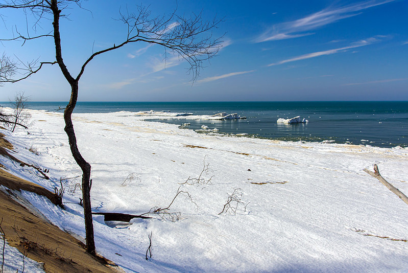
Just a few days earlier, Lake Michigan was filled with ice as far as the eye could see. Last week, we hiked through thigh-deep snow in this same spot to view the ice mounds on the beach, this week, they're almost gone. Only a couple of days of 40 degree weather and the floe ice melts quickly, and soon, all of this ice will be gone as well - it's meteorological spring already.
While our goal was to hike to Kintzele Ditch last week and this week, we approached from a different access this time - Central Beach. Closed for quite some time because of erosion and well water problems with the remodeled washrooms, it's a nice change to access the beach quickly via our old standby trails.
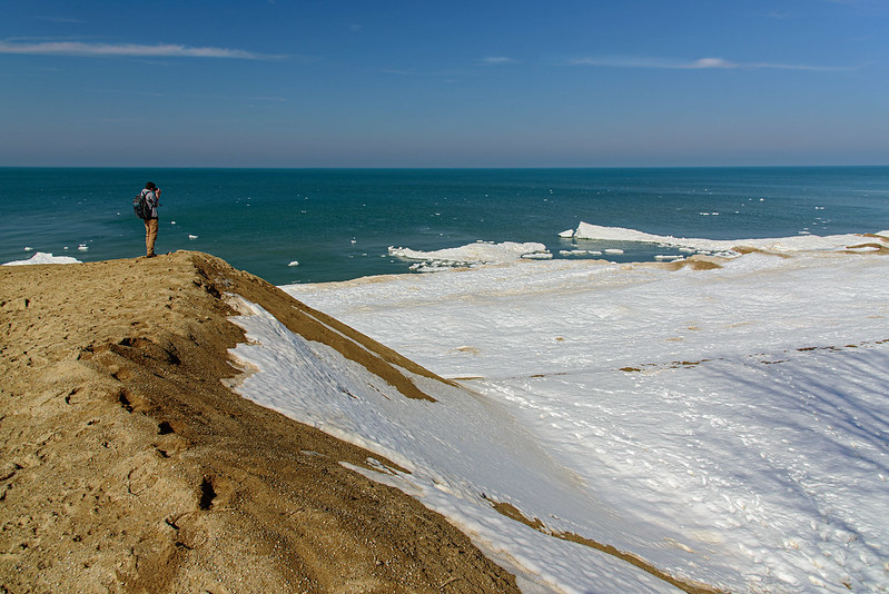
The remnant ice took on the look of the arctic, like small icebergs floating just off shore. But these mounds stood at the bottom of the lake and rose up a few feet above the water.
Some years, these ice mounds can rise 15 feet above the water - as high as the waves can throw the ice chunks when they pound the shore. This year didn't produce the usual number of mounds or ice volcanoes, but it was pretty none-the-less.
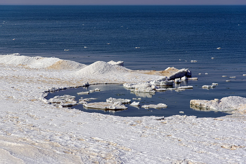
Just as it does when the ice forms, when it melts, it creates interesting structures on the beach. This cove is being enlarged little by little as the waves move floe ice into and out of the ice shelf. The beach was lined with similar structures as we hiked the shore to Kintzele Ditch, each unique in size and shape.
My only regret was not having our kayaks- it would be amazing paddling in and out of these small coves near the ice mounds. Maybe next year.
Subscribe to:
Posts (Atom)


