Behind the Ice Pillars of LaSalle Canyon


Behind the Pillars 
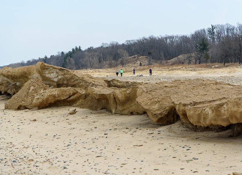
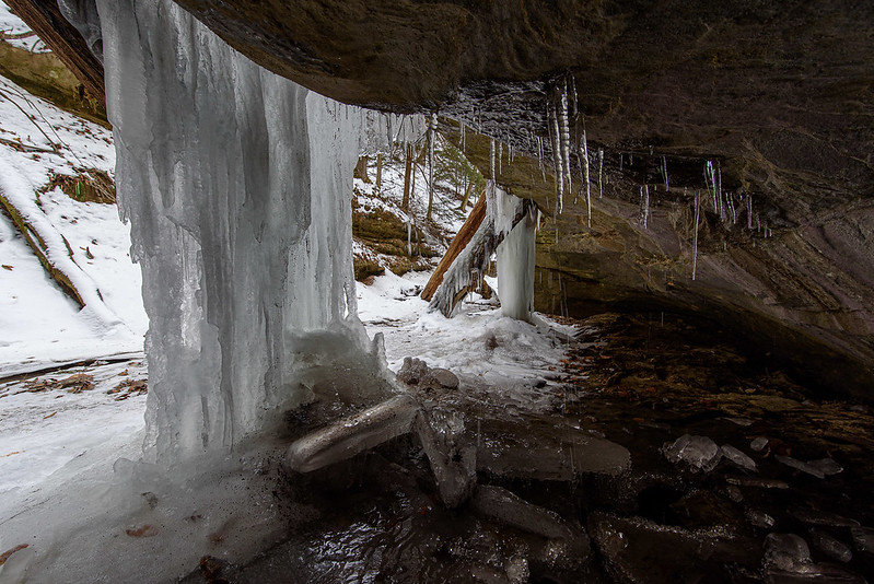
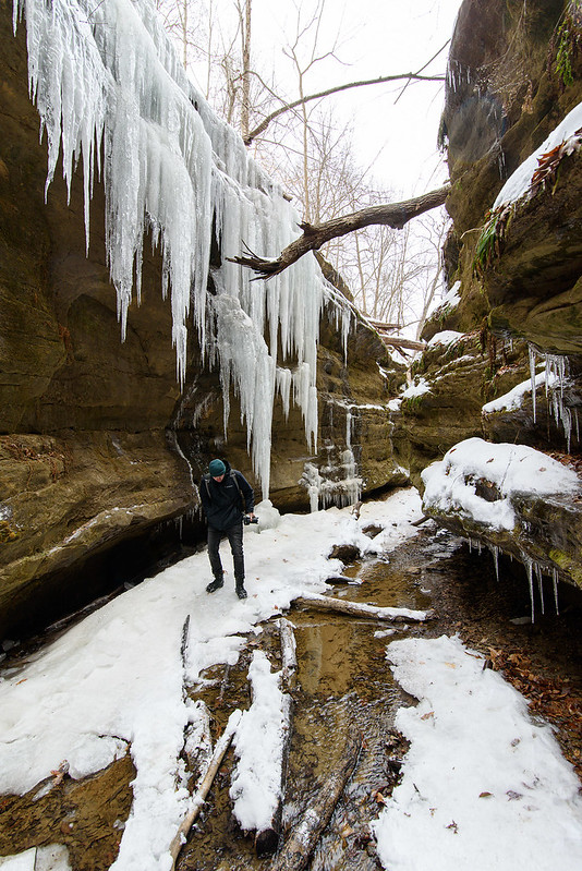
There are a couple of frozen waterfalls in Starved Rock State Park that one can easily walk behind, and the most popular is the one in LaSalle Canyon. 

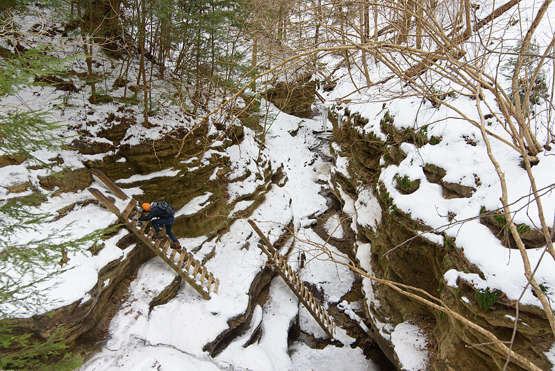
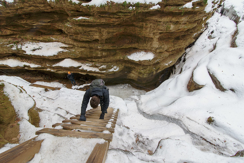
A bit over a mile walk from the nearest parking area, and what seems like 300 stairs, the canyon is tucked deep in the rock formations, well off the river trail. 

This canyon has gotten more and more popular in the winter over the past few years, and for good reason, it's fun to walk behind the ice.
  Panoramic View Behind the Falls 
Careful not to get too close to the ice formations, you can walk completely around them without any trouble. Other icefalls have smaller spaces behind and you'll need to crawl or squeeze to access them. 

There are almost always cracks in the ice columns due to water movement and the weight of the ice. Seeing this, I always keep my distance; a person can be crushed if these let loose. 

The approach to these icefalls can be slippery - of course, they're made by running water and the water has to flow away from the falls. Ice cleats are a must unless the weather makes the surface slushy.
  Ice Pillars 
 In what I refer to as "Good years," the ice fills in the space between the ice columns creating a wide ice curtain that is relatively thin (maybe a foot thick) and the sunlight passes through the ice. This year was just a bit underwhelming when compared to the "Good years," but perhaps after this week's warm up, there will be a freeze and the curtain will once again be drawn across the overhang.

Approaching LaSalle Canyon

LaSalle Sunburst

One of the most popular canyons of Starved Rock during the cold, winter months is LaSalle. It's a bit of a hike from any trailhead and parking lot, more than a lot of people are up for in the cold, but well worth the trek. The approach to the waterfall is lengthy, probably a quarter mile or more from the river trail, and it builds up suspense. Will the waterfall be completely frozen or partially? Will it be a complete curtain of ice, or columns? 

On this trip, following the frigid weather last week, the waterfall was frozen. And relatively crowded for such cold weather - it's good to see so many people exploring the trails. While it can be a bit frustrating waiting for people to move along, I like to include people in the image for scale and interest. There are, however, some easy ways to capture multiple images of the exact same scene in crowded areas and stack them to remove the people, so it could be done.

Taking in LaSalle Falls

This is certainly a time when people stop and take in the scenery, some stopping for a brief view, while others sat in the snowy canyon for 30 minutes or more. As we ventured around the ice, the sun began peeking around the rock formations creating sunbursts and some very warmly illuminated rock surfaces. With an F stop of 14 or more, the camera will take some great sunbursts, depending upon the lens used, and a bit of technique and luck. 

My friend Ken is the master at capturing sunbursts - he's pictured directly in front of the sunburst in the first image.
  Entering LaSalle Canyon  
As one approaches the end of the blind canyon, there are two waterfalls, one obvious at the very end, and another right at the entrance flowing from the large waterfall into the pool that flows into the Illinois River. It's a bit uneventful in winter, yet you can see it in the foreground of the image above. 

The weather is set to warm up this week with some rain heading this way. Too bad it won't stay cold for a few more weeks, I'd love to see how large and intricate these icefalls would get with a bit more time. But, the rain might just help these grow a bit as the temperatures drop again in the evenings. I'll have to head out again soon to check the progress.

Frozen French Canyon

Visiting the Falls in French Canyon

Visiting French Canyon in winter can be challenging. The path to this blind canyon is at times a stream, and in winter, it's ice cascading over slippery rock; ice cleats are a must. Several years back, I overheard a park ranger advising some other visitors to stay out of French Canyon in winter, "It's treacherous, nobody should even try." At times, I agree, and if I'm wearing ice cleats I disagree. There are no steep areas where safety is an issue, and if you straddle the narrow creek on your way up to the falls, you'll be safe. 

On this visit, to my surprise, the canyon was icy, but slushy overflow ran on top of the ice, making the hike into the canyon very wet, but not a slippery as usual - a trade off.
  Frozen French Canyon 
Once inside, the 45 foot tall frozen waterfall came into view, and after a week of sub zero Fahrenheit weather, the falls were beautifully frozen. In these canyons, the clear ice often takes on the colors of the surrounding environment, browns, yellows, and greens. This particular icefall begs to be climbed, but ice climbing is only allowed by permit, and at specific canyons - French Canyon was not on the list this time. 

Starved Rock State Park in Illinois is the second most popular visitor attraction in the state, following Navy Pier in Chicago. One visit to Starved Rock and you'll wonder why Navy Pier is even on the list. 

In all seasons, this park is spectacular, but in winter, it's magical. In years past, I was often the only person in each canyon, only bumping into a person here and there, but lately, the word has gotten out about how beautiful this place is in winter, and it's unusual not to see anyone in the canyons.
  Warm Canyon 
 Even in the 8 degree Fahrenheit weather, the sandstone and conifer trees bring warmth to the hike. And no matter how cold it is, the canyons are always warmer. Protected from the winds, the canyons bring a bit of relief after hiking along the exposed riverbank. Or perhaps when you enter the canyon, you forget about the weather.

Cold Bath for a Giant

Devils Bathtub

A bit more than halfway from Mattiessen's Cedar Point to Lake Falls is a small but dramatic waterfall cascading into Giant's Bathtub, a small pond on the upper dells. In times of high water, it's a bit difficult to reach without getting wet, but it's generally well worth the trek. If your balance is good, you can stay dry by stepping on rocks, logs, or whatever happens to be in the stream at the moment. This waterfall can be reached from an access upstream as well as downstream, but in both cases, you need to walk through the stream at some point.

The best way to see this waterfall, I think, is from the downstream approach, from Cedar Point. The site reveals itself as you walk up to it, rather than seeing it from the top when you're almost falling over it. Heading to the Lake Falls access, you'll need to walk through the stream at the very top of the waterfall. This can be a bit tricky if the surface is icy or otherwise slippery - one slip and you can end up falling down into the falls, and into Giant's Bathtub. Be prepared to get your shoes wet as you walk through the 6 to 8 inch deep running stream.

Visiting lake Falls


A Visit to Lake Falls 
It's impossible to visit Starved Rock State Park without a quick hike through the dells of nearby Mattiessen State Park. Lake Falls, a manmade waterfall at the head of the upper dells, is a popular spot to visit. It's a quick hike along a fairly level trail, but you need to head down about 100 stairs total - generally not a problem for most people, it's the way back up that may be taxing. 

More scenic routes lead to the same waterfall, one includes walking along the floor of the canyon through the shallow stream, and the other require a bit of trail and a bit of traversing across the stream. Of course, this all depends on the water levels, and on this visit, the level was a bit higher than normal, so waling from one waterfall to another required getting wet or doubling back and taking another route.

  Bright Falls 

In anticipation of cold days when the waterfalls and the stream are frozen, I took note of the areas of the stream that were deep, and where they are shallow. Using this knowledge, I can remain dry (and safe) when I return to the frozen canyon - knowing where the deep areas are now, can help me avoid a cold fall through the ice later. None of the areas are very deep, but waling back to the parking lot soaked to the waist is no fun in zero degree weather - ask me how I know! 

Unlike last year, with any luck, the weather will turn cold enough to freeze the waterfalls this winter, and I'll be standing by.

Out of the Shadows


Starburst Canyon

On an unusually warm winter day, the streams and waterfalls in the canyons of Starved Rock State Park were flowing with water from recent rain storms. Usually at this time of year, ice would begin to form along some of the streams and waterfalls, setting the foundation for the solid icefalls to come in the upcoming weeks and months.
 
Late in the afternoon, the sun illuminates and warms only portions of the canyon walls, creating an interesting sunburst, and dramatic contrast between the canyon walls and the floor. Access was certainly easy due to the lack of ice - winter can be dangerous here in French Canyon, where ice cleats are a necessity just to gain access to the canyon. Today, we barely got our boots wet.

  Out of the Shadows

The drama between the shadows and light in these canyons is always interesting, but today's sunlight made them even more dramatic. The photographs appear black and white in the shadows and warm color in the light, equally amazing in person. 

This was the first trip to Starved Rock in two years; with no ice build up last year, I kept away. But even in the barest, most boring of times, these canyons still hold a beauty worth exploring.

Between the Dunes

Morning at the Interdunal Pond

It's been an unusually warm and dry winter so far, and this is evident when visiting the Indiana Dunes National Park. One way to see we're lacking a bit in moisture is the level of this interdunal pond; it's quite low. Usually, the pond extends to the taller grasses by the foot of the surrounding dunes, but now, only a fraction of the water is in place. This isn't extemely unusual, the water levels often fluctuate, but I'm so used to seeing this pond larger.

An interdunal pond is a small body of water that forms between dunes. There is really no escape for the water that ddrains into this area, other than evaporation or absorption, so it collects into a pond. These type of ponds are havens for all sorts of animal life including birds, frogs, turtles, lizards, insects, and small mammals. The dunes can get quite dry in the summer months, and these interdunal ponds can provide support for these creatures. Of course, this particular dune is just a few hundred feet from Lake Michigan, but some of these small animals will never travel that far.

A View of the Pond

As with so many other views in this national park, this view looks as if it comes from a totally different region, something more often found in the western United States. The conifer trees here around this pond, and throughout the park mark the farthest southern reach of Jack Pine in the country. These glacier leftovers were able to remain behind when most others died off due to the change in climate after the last ice age thousands of years ago. The Indiana Dunes National Park boasts the fourth most diverse variety of plants of any US National Park. A total of 1130 native species of flowering plants call this area home - and you thought the Indiana Dunes National Park was just a beach with hills.

Between the Dunes

This photo better illustrates the location of this interdunal pond, it is completely surrounded by dunes. It's a shame one can't explore all the sides of this pond, but I imagine venturing around this pond could disturb quite a few living things that rely on this unique environment for their survival.

Michigan City East Pierhead Lighthouse in Winter

Michigan City Lighthouse

A winter visit to Lake Michigan would not be complete without a visit to some lighthouses. While the Michigan City East Pierhead lighthouse is rarely covered in dramatic ice, it's always beautiful nonetheless. A lot of the Michigan lighthouses are covered annually by thick layers of interesting ice created by high waves and wind, but the MC lighthouse is surrounded by boulders in the water that break up high waves and prevent powerful splashes. These splashes and sprays are what eventually cause the thick ice coatings on the lighthouses and the piers. Here, they only cover a bit of the catwalk uprights and the pier surface.

Just a few hours before this photo was taken, Trail Creek was full of pancake ice. Here, the winds blew the ice far out into Lake Michigan, leaving only a small amount trapped in the bend of the pier. This ice can be mesmerizing to watch as it rises and falls with the waves. The pier can be very hazardous when it's covered in ice. The surface is sloped to water washes off easily, so this incline can be very slippery in winter, and falling could result in a slide right into the water. Even though you can see how dangerous this could be, families with small children were walking on this ice to get closer to the lighthouse.

East Pierhead in Winter

The view from the shore was dramatic as well in the early afternoon sun. The ice was brilliant white against the blue water and sky. What took only a week to create in the cold weather, is probably gone already after three days of warmer weather.

The Blowout


The Blowout

Once up the dune ridge trail, we made our way to the lake side of the dune. From this vantage point, the blowout could be seen, the area of the dune that was eroded from wind. Dunes are the most unstable landforms, and seeing a blowout reinforces this. No matter how much vegetation is on a dune, something can upset the balance and create a bare spot creating a blowout. Once established, a blowout will tend to increase in size as the edges erode further and further. The loose sand of the blowout will fall to the bottom of the dune, or can be blown over the top of the dune by high winds. Once the sand begins to blow over the dune, it is deposited on the leeward side, building the dune on that side. This is called a living dune, as the dune seems to move inland by itself.

The View From the Blowout

The view of Lake Michigan from the top of almost any dune is spectacular, combined with sun and floating ice, it becomes even more special. This year, there is very little ice on the lake (so far) so any is a sight to behold. The beach in the photo above is about 80 feet below, and its about 700 feet north to the water. It doesn't look that high or distant until you begin to climb up, or walk to the water. A few trails can be seen if you look closely. On clear days, the Chicago skyline can be seen from this vantage point; the city is approximately 30 miles across Lake Michigan as the crow flies.

Dotted With Conifers

As dunes form and evolve, different vegetation begins to take hold. Here, conifer trees can be seen dotting the marram grass. They're generally the first wood to take hold, and seem to be declining in numbers here at the Indiana Dunes National Park, at least in my estimation. There are a few places where they seem to thrive, West Beach is one area, and it's very special to hike through these conifer micro-forests. The sights and odors are so different from the surrounding area.

Hiking The Ridge Trail


The Warm Colors of Winter 
I love bringing people to areas they've never seen, and this hike was even more special. My brother John came along for a winter hike through the winding, hilly trails of what I call the Ridge Trail. This is not the official name of the trail, it's a nickname I've given it - I honestly don't know the "real" name of this trail, and don't particularly care either. This trail starts out on the Lake Michigan beach, heads off into the grassy dunes, then through the wooded dunes to the ridge where it meanders for a half a mile or so around savannas, woods, and blowouts, until it comes back to the beach. It's a quick hike for a cold or hot day, and a great place to introduce someone to the Dunes.
 
Hiking The Ridge

Of course, John has been to the dunes before, but not to this particular area, and although I like to use this relatively short trail to introduce people to the dunes, he could hike for hours non stop, and we did continue after this trail.
 
One thing I like to do is to keep people looking ahead as they hike, then stop in certain places and ask them to look back. Here, John was hiking, and a few moments after this photo, I told him to look behind him. The view of the rolling dunes, conifers, and partially frozen lake are a relative surprise when you turn around. You don't realize the expanse of the area until you stop and take it all in.

The Path Ahead

Just ahead is a large dune with a winding trail up to the top. This is the backside of a large blowout - an area of a dune that has been eroded by wind and/or waves. The area looks like a large, bare depression in the dune, it's quite striking, but from the backside, everything looks normal. As we hiked further up, we would encounter the blowout, and the way down from the tall dune.

The Gelid Shore

Ice Fault


So many weeks of warm weather finally turned cold enough to form ice on the shoreline of Lake Michigan. Unlike most previous winters, the shelf ice only extends a few meters out, and it's only about half a meter in height. Bitter cold temperatures combined with high winds create the "best" shelf ice and mounds on the shoreline. On this day, the ice was being pushed off shore by southern winds. Looking closely at the ice on the lake, you can see it out in the middle of the lake.


Gelid Shore

Visitors to the lake in winter often see these tall mounds of ice and figure they're thick and solid enough to walk on. This day proves that shelf ice is not attached to the bottom of the lake - in fact, it's floating with the exception the first few meters where the waves break. Here, it's thick enough to touch the bottom, but that doesn't mean it's safe. 

The large mounds of ice seen here now away from the shore, were once attached to the ice near the shore. The winds blowing off shore moved them slowly to their positions now. Imagine, venturing onto these mounds when they suddenly break off and begin floating out!


Ice Line

At the times of high winds, the ice mounds up often 10 or 15 feet tall. In times of low winds, the ice simply forms on the surface of the water. These jumbles of floe ice seen in the image above will form after the mounds and freeze together into this boulder-like texture on the water's surface. Then, if winds come again, mounds will form on the outer side of these flat areas, as the ice builds up. It can often extend 100 meters into the lake. At times, the floe ice covers all of the water that can be seen from shore, perhaps a mile or two out.

First Flowers on the Trail

First Flowers on the Trail 
While we've had some very warm days so far this Spring, flowers are only just beginning to appear in the woods around the Indiana Dunes National Park. The first two flowers I encountered this year are non native crocus (at least that's what I believe they are). It was interesting that these were the only dots of color on the still-brown landscape of the wooded dunes. 

 The Dune Ridge Trail is a short, half mile or so loop beginning at the Kemil Beach parking lot, that heads up to the ridge of a dune overlooking the Great Marsh. There are more trails that wind around the area below, they were once roads with homes on them, but now nature is taking them over. These are some of the areas I hope the park develops into marked trails - the locals know about these and hike them all the time. It's an interesting area of dune, marsh, and woods that has an old artesian well flowing next to a closed road.
  Woodland Flower 
 From this point forward, the park will come alive with so many different flowers and plants, it will change almost daily. One of the best locations for wildflowers in early spring is the heron rookery, I'll head there very soon.

Dune Views

View From The Dune Trail 
Walking through the rolling dune landscape in early Spring offers some views not normally seen when the trees green up with leaves. In this case, the lake is easily seen, and the matted, dry grasses allow you to see the trails through the dunes. 

This particular trail is a bit strenuous, only because of the loose sand and the constant change in elevation, but because it's up, down, level, up, down, you get a bit of a recovery period every few   minutes. If I were training for a run or on a cross country team, this is where I would train! 

Some dune progression can be seen here, beach, grassy foredune, conifers, then oak. But because of the ever changing nature of the dunes, there are breaks in this progression, making it anything but linear. Here, grasses are behind conifer sometimes, it's just the way the dune formed and changes every so often.
  The Other Side of the Dune 
Once around the tall dune, we are greeted with a view of the lake, and a relatively new living dune. It's called a living dune because the wind keeps pushing sand from the beach up and over it, preventing things from growing on it, and moving it inland at a slow pace. This dune has grown over the past few years, and while I can't tell by looking at it, it has moved inland a bit as well. 

If you look very closely along the beach, you'll see some visitors walking along - tiny dots on the sand. This area is much larger than it looks in photographs, only noticed when you look for a source for scale, or you experience it yourself. 

 The wet and warmer weather are quickly greening things up, soon early wildflowers will dot the grasses.

Nature's Sandcastles

Nature's Sandcastles 
I've seen this phenomenon many times at the Indiana Dunes National Park, miniature sand castles formed by dripping water. Every time I see this, I'm intrigued. I'm also brought back to my childhood vacations in Florida where a friend from Pennsylvania made sandcastles in an unusual way. He would begin by filling a bucket with sand and water, then he would take a handful of the saturated sand and let it drip out of his hand down onto the beach where it would form towers similar to these! Somehow, he must have learned this from someone who has witnessed this. 

I've been told sandcastles built this way are called "drip castles" and that certainly describes this method perfectly. People have simply taken the physics of water and sand, and used it to their advantage to create strong castles.
  Sandcastles 
Judging by the state of these drip castles when I arrived at the beach, and then again when I made my way out, these take quite a long time to create. Not terribly long, but hours for sure if the water isn't dripping too rapidly. If the water drips too fast, I think the sand will simply wash away instead of stacking. I've also seen in the past, where the water dripped directly onto a rock and instead of the sand building up, it washed away the sand around the rock, but the sand directly under the rock was protected, so the rock was basically resting on a sand pedestal. 

 These are just another fleeting formation created by nature here at the Indiana Dunes National Park. Every visit is different, even if you walk the exact same path.
  Sand Layers 
To get an idea of how much change takes place each day, take a look at the photo above showing an area of beach that was washed away this winter. This "cliff" is three or four feet tall and shows layer after layer of sand, rock, and pebbles. You can look at these layers and read how the lake behaved at that time. Some harsh waves wash away the sand and expose rocks, while more gentle waves deposit the sand over the rocks. 

Every moment of every day, the waves and wind are working at changing the beach - it's a natural cycle that can't (and shouldn't) be stopped by human interference.

Green Up

Green Up 
It seems every year there is at least one warm up in February, this year there were a couple of days near 50 degrees, but once March arrived, we had our first 70 degree day of the year. Hiking along the dune ridges on this warm day sure felt summer-like (I can't wait). I think even the trees thought it was summer, judging by the deep green color of the coniferous trees. 

It doesn't take much rain or warm weather to get them to green up, especially in this environment. The sand seems to keep in the heat - I may be imagining this - but the vegetation here at the Indiana Dunes National Park responds just a bit different than those a few miles away. I would think the environment here is quite harsh in comparison; sand drains well, so moisture doesn't remain in the ground too long, the sand gets very hot, it doesn't have a lot of nutrients to sustain plants. This must by why the native species do so well here, while some other invasives don't - at least on these dunes. In addition to the plant life, some wildlife thrives in these areas and practically nowhere else in the area.
  Rolling Dune 
 A very small amount of snow is left over from the last winter storm, only in the shady spots and probably where the snow drifted into deeper piles. The snow looks more like a white cloth left on the ground - like the old television shows and movies where they simply piled some cotton cloth in the corners to represent snow. 

Of course, two days after the summer weather, it snowed a bit. The best thing about spring snow is the fact that it doesn't last more than a day or two! This area may not look expansive, but when you hike it, you would realize just how far it is from the place I'm standing to the distant trees. We didn't run into too many people so scale is difficult to represent in photos.

The Last of the Shelf Ice

Crumbling Ice Shelf 
It never lasts for long, but this year, shelf ice is disappearing early with the recent warm weather. Temperatures in the low 70s this past Saturday, melted almost every pile of snow and ice around, with the exception of the huge chunks of shelf ice created by the crashing waves of Lake Michigan a few months back. They're so large it's taking a bit longer for them to disappear. 

These remnants are relatively safe to explore now because they are completely on solid ground, some ten feet from the lake. The only danger would be if a chunk of ice broke off and fell to the ground, anyone underneath would be crushed. Without the waves undercutting the ice, the chunks should stay intact and simply melt.
  Between the Water and the Dunes 
Summer-like temperatures brought everyone outdoors this weekend, and many flocked to the Indiana Dunes National Park, perhaps to enjoy one last time visiting before the admission fees begin at the end of March. $45 for an annual pass, $15 for a weekly pass. I hope the fees go to creating more trails from the old roads and paths that wind behind the dunes. 

It's easy to see how someone who is unfamiliar with the area could mistaken the ice for solid ground. Sand and rocks are incorporated in the ice, so rocks are the size of softballs, so it would seem you're on solid ground when in actuality, you're on ice. The power of the waves picks up bricks and rocks and tosses them onto the ice where they become mixed with snow and ice.
  Edge of the Ice 
This is indeed the only time it's relatively safe to walk on the ice along the Lake Michigan shore. The ice is not floating on the water, so there is no way to fall through into cold water. It's very interesting to see the ice from the "other side", but a lot of fracturing and erosion has happened, so it's not quite as it was when the waves were forming it. Still, it's a different vantage point than the middle of the winter.

The Icy Canyon of Trail 3

Behind the Ice 
Trail 3 of Turkey Run State Park offers so many sights in every season, and winter is certainly one of the more dramatic times along this trail. While the park has some tall waterfalls that freeze in the cold weather, these canyons have countless large icefalls created from the water seeping out from the canyon walls, or overflowing from the ground above the canyons. These icicles create seemingly endless winter features that can't be ignored. Some of these icefalls are large enough to explore beneath or behind. This particular formation was about four feet tall, so we had to crawl into the overhang to view the ice. 
Not quite a difficult as some of our explorations into ice caves and canyon overhangs, but just as interesting to see how the ice clings to the rock. 

 These canyons are also home to some mosses and ferns that get completely covered in ice, yet stay green and appear as if they're still growing in winter. I'm sure they're laying dormant, and I assume they are specially adapted to this particular environment.
  In the Canyon 
 Here's a wider view of this portion of the canyon. Rock, moss, trees, logs, snow and ice give the eye so much to investigate. As with so many parks and natural places I explore, things change every time you visit - even if you visit everyday.

Breakup Begins on Lake Michigan

Pancake Ice Cove 
Things happen quickly at this time of year. Single digit temperatures at night, snowfall one day, 45 degrees the next day, and the cycle repeats over and over until Spring. The warmer temperatures and the high winds we've experienced last week have broken up most of the solid ice on Lake Michigan. 

Only the thicker chunks of shelf ice remain, along with a large amount of floe ice that is driven toward the shore with the waves. The breaking ice creates little coves in the shelf ice, and the floe ice chunks are then trapped inside, pushed around by the waves, they hit the edges of the ice and collide with each other. These collisions spin the ice slowly, and form disc-shapes called pancake ice. They do look a bit like pancakes. Almost every spring I can find pancake ice in these relatively small coves of ice at breakup. Pancake ice forms all winter, but mostly when the water is mostly liquid and the wind is pushing things along. Some of these pancakes can grow very large, sometimes larger than a car.
  Breakup Begins 
 Our hike took us up to a relatively secluded place along Lake Michigan; most of the trail used to be asphalt roads with homes on both sides. The houses and almost every sign of them are now gone, with the exception of some plants normally associated with home gardens, and the tell tail-flat spots on the dune where driveways used to be. 

Then the trail turns into a narrow path used mostly by deer (judging by the footprints) up to some dramatic dune blowouts and overlooks. It's from this point where you can obtain a panoramic view of Lake Michigan as well as the landscape for miles inland. there aren't too many places left at this park where you can get this view of the landscape - most have been closed for some poor excuse or another.

The Icy Canyon

Flowing Ice 
Nearing the end of our hike through the canyons of Turkey Run's trail 3, the canyon narrows once again. Though not as deep as other portions of the park, this area has many more areas where the water cascades slowly over the canyon walls. In warm weather, there would be evidence of moisture, and not much running water, but every drop of water now freezes and creates huge icicles on the rocky walls. 

Not spectacular waterfalls, yet these somehow overshadow some of the frozen falls here, because of their number and intricate details. The cascades line the canyon walls in this part of the park, creating an impressive and breathtaking environment for a winter hike.
  Cascading Ice 
Careful not to walk beneath any of the free-hanging ice for fear of portions falling down (these can weigh a ton or more), the view is spectacular from below. 

Most narrow canyons are relatively dark, but somehow the canyons of trail 3 have an unbelievably perfect light all year round. In warmer weather, the light is filtered through the green leaves of the trees above, casting a yellow-green light into the depths of the canyons. It's something everyone I've brought to the park notices.

  The Icy Canyon 

 As one exits this canyon, there's a desire to turn around and view it again from the opposite direction. Maybe we would have done that if portions of this hike weren't so difficult due to high water and icy conditions. Then again, what lies ahead on the trails we didn't get to see yet? A day isn't enough to soak in all that Turkey Run has to offer.... we'll be back!

Descending the Ladders

The Ladders of Trail 3 
About a mile after navigating the waterfall and narrow canyons with swift running water, we reached The Ladders. Quite literally, these are ladders built to assist hikers into Bear Hollow, a narrow canyon otherwise unreachable without climbing gear. 

There are three tiers of rock the ladders span, each about 15 feet tall, so not terribly high, but rather slippery. One summer, one of my sons slipped while waiting for others to climb down the ladder. I heard a scraping sound and then a splash, he slid down into a knee-deep pool of water about five or six feet below on a narrow ledge. Luckily he didn't fall all the way into the canyon below. At the time he was about six feet tall, so he found his way back up with little effort. One of the reasons it's become habit to stop and look before I move anywhere after taking a photo - even when I'm firmly on the ground.
  Narrow Canyon 
The canyon walls are filled with intricate cuts and textures, and can be seen from the vantage point of the ladders. It's interesting how may plants actually grow on these walls, and even in winter are snow and ice covered, but still green. 

Another trail intersects trail 3 at the ladders, you can see the boardwalk at the top of the image. Most trails between the ladders and other portions of the park are more wooded than canyon, with the exception of the trail through Bear Hollow, which continues all the way to Sugar Creek.
  Down the Ladder 
The ladders are rather deceiving in height, they are only about 15 or 20 feet per level, but when you actually look down to the floor of the canyon, it's quite a distance. You can see one person standing at the foot of the ladder on the canyon floor. This gives a bit of perspective of the height of this portion of the canyon. 

While it would be quite exciting to get down without the ladders, in winter, it's all but impossible without climbing gear. In fact, the ladders are difficult enough with 4o pounds of camera gear on your back, a camera on a strap, and worst of all, ice cleats on the boots!