Calm Summer Morning

Calm Summer Morning

Two boys play in an unusually calm Lake Michigan on a hot summer morning. Throwing stones into the lake, skipping rocks, and hunting for fossils were the top activities of the morning.

Two of the most popular beaches have been closed this summer - Mt. Baldy (closed to the public since 2013), and Central Beach (closed since July). This puts a lot of pressure on the few beaches left - visitors must arrive before 10 am for a chance at a parking space.  The beaches themselves do not seem overcrowded, since there is little parking available.

With any luck, the two beaches will reopen next year, allowing visitors to walk once again on the sands of Lake Michigan next to the wooded sand dunes.

Harry Evans Covered Bridge

Harry Evans Covered Bridge

The 65 foot long Harry Evans Covered Bridge spans the small Rock Run Creek 1/2 mile from the town of Coxville. This bridge is still open to vehicular traffic on this out-of-the-way gravel road, but a concrete ford built just downstream allows larger farm vehicles to cross the creek.

Through the Bridge

Built in 1908 using a single span Burr Arch design, the bridge gets its name from the farmer who owned the land near the bridge at the time.

Harry Evans Covered Bridge

This covered bridge was in the most peaceful area of all the bridges we visited.  So remote and quiet, we could have spent hours with our feet in the creek and probably would not have seen another person.

harryevansspansm

Summer Skyline

Summer Skyline

A jetskier enjoys the waters of Lake Michigan - just off Monroe Harbor- on a hot summer afternoon. One of the best places to view the Chicago skyline if you're a land lubber is from Solidarity Drive and the breakwater around the Adler Planitarium.  The skyline is clearly visible, behind Grant Park, and the lakefront trail, with Monroe Harbor in the foreground- an all around great combination.  It's best to arrive early in the day when the buildings are washed with sunshine, or after sunset when they are illuminated.  Anytime near sunset the buildings will be in shadow because the sun sets behind them.

Many years ago, I used to walk out on the Easterly Breakwater to view the city, but the last few times I've tried to access it, it's been closed.


Meteors and the Milky Way

Milky Way with Meteors

A dark summer night in rural LaPorte County, Indiana presented a great opportunity to view the Milky Way Galaxy.  The crescent moon hadn't risen yet, so the sky was very dark - except for the light pollution from big cities many miles away.

While gazing up at the stars, we noticed a meteor or two traverse across the sky, so I was hoping my camera captured one or two.  I used exposures from 10 seconds to 20 seconds, and in the photo above, found four meteors, one very difficult to see unless zoomed in.

Milky Way

At first, I thought the light streaking at the bottom left was an airplane, but in a 20 second exposure, the light would have appeared like a zipper, with dots every second as the plane's lights flashed.

I remember staring up at the sky on a warm summer night as a high school kid, in a rowboat in the middle of a small lake, and viewing the Milky Way. Shading my eyes from the lights on the shore, and letting them adjust to the darkness.  It seemed the longer I looked up, the more stars I saw. I was able to experience that same feeling again last night.

The Mecca Covered Bridge

Mecca Bridge Spanning Big Raccoon Creek since 1873, the 150 foot long Mecca Covered Bridge is a historical centerpiece of the small town of Mecca, Indiana. Once called Maidstone, the town may have been renamed after a group of Syrian Muslims settled the area and frequented the mill on Big Raccoon Creek. The Bridge to Mecca The bridge is no longer open to traffic, US 41 passes a short distance away from the town, but the residents adore their covered bridge. The bridge is decorated for Christmas, and caroling takes place inside. At Easter, a sunrise service is held in the bridge. We noticed old electric lights inside the bridge - no doubt easily added due to the proximity of "modern" electric lines so close to the bridge. Gazing out the Window The bridge contained a single window allowing people crossing the bridge to view oncoming traffic on the curving road ahead. A small park including an old schoolhouse are on the grounds, making this covered bridge easily accessible for drivers who wish to stop and explore the bridge without blocking traffic. Mecca Covered Bridge

Roseville Covered Bridge

Roseville Covered Bridge This 263 foot long covered bridge is the third bridge built across Big Raccoon Creek at this site. In 1910, the previous bridge burned and a concrete bridge was considered as a replacement. Instead, the Roseville covered bridge was constructed, and remains today. Not far away in Armiesburg, a concrete bridge was built in 1917 to replace the wooden covered bridge, it collapsed after only 13 years! Roseville Covered Bridge The Roseville covered bridge uses two Burr Arch spans to cross the creek, and has a cut sandstone foundation. It's set on a gravel road, in an out of the way portion of Parke County, and only a block away from a very small cafe and bakery, very easy to miss while driving on adjacent Coxville Road. The local people seem to care for this bridge - an assortment of colorful flowers grows near the entrance.

Bridgeton Mill and Covered Bridge

Bridgeton Covered Bridge and Mill Indiana's most famous covered bridge, is the 267 foot long, double span Burr Arch bridge in the historic town of Bridgeton. Adjacent to the old Bridgeton Grist Mill, the original bridge was built by J. Daniels in 1868. Destroyed by arson in 2005, the community gathered to rebuild the bridge using the original plans and traditional materials and methods. The current bridge was completed in 2006. Bridgeton Mill and Covered Bridge The bridge spans Big Raccoon Creek at the dam constructed for the mill. The flow of water over the nine foot tall, 220 foot wide dam is usually contained to only a portion of the dam, but in high water situations such as in the photo above, the water cascades over the entire structure. The oldest operating grist mill in Indiana, and possible the entire region, Bridgeton Mill has operated in some way for the past 180 years - from milling wood to grinding grain. Open today for demonstrations, visitors can watch as grain is milled to flour using the 2000 pound French Buhr stones, and feel the floor vibrate as the massive stones turn. Bridgeton Bridge Approach Certainly one of the most interesting covered bridges in Parke County, Indiana.

The Neet Covered Bridge

The Neet Covered Bridge
Six miles southeast of Rockville, Indiana, stands the Neet Covered Bridge. Said to be the last covered bridge built by Joseph Daniels (a well known covered bridge contractor) the 126 foot long bridge has spanned Little Raccoon Creek since 1904.

Neet Covered Bridge Interior

Windows were often built into these structures when the road curved near the bridge. The windows allowed persons crossing to view any traffic approaching the bridge from the road ahead.  This explains why windows were often only on one side of the bridge, and sometimes only on one end.

Neet Covered Bridge Entrance

Closed to vehicular traffic today, the Neet Covered Bridge makes the perfect little rest stop when driving or biking this lonely section of Bridgeton Road. While resting, visitors can enjoy the historic bridge and the beautiful views of the countryside.

A Covered, Covered Bridge

Covered Bridge
Partially obscured by trees, the 92 foot long Mill Creek Covered Bridge almost becomes part of the surrounding landscape. Still in use on Towpath Road, 2-1/2 miles from Tangier, Indiana, the 1907 structure spans  Mill Creek at a point once called Thompson's Ford (a ford is a shallow area of a creek or river which is often used for crossing). This area was very close to the historic Wabash and Erie Canal, hence the name Towpath Road, and a third name for the bridge: Tow Path Bridge.

A Tree Covered Bridge

A small village once existed near this bridge; within it, a flour mill operated for several years.  The dam for the mill washed away in 1888, and was never replaced.  There are no remains of the village today.

The creek beneath this bridge is quickly eroding the bank, forcing some structural enhancements over the last few years. Nonetheless, the bridge remains open to traffic.

The Beeson Bridge

Walking the Beeson Covered Bridge
<
Originally built 1n 1906 across Big Raccoon Creek, the Beeson Covered Bridge was rescued and moved to it's current location over Williams Creek. The bridge is no longer open to vehicular traffic, but serves as the entrance to Billie Creek Village, a collection of historical buildings including a general store, log cabin, church, and print shop.

hidden bridgesm

The Beeson bridge is a single Burr Arch spanning 55 feet, constructed of wood on a concrete foundation.Named after the family whose farm was located near the bridge, the Beeson covered bridge was reunited with the family log cabin when it was moved to Billie Creek Village in 1979.

<Shady Bridge
<

100 Years - The Bowsher Ford Covered Bridge

Bowsher Ford Bridge

Carrying traffic over Mill Creek, the Bowsher Ford covered bridge celebrates her 100th birthday this year. Built in 1915 by Eugene Britton, the bridge resides on a gravel road about two miles northwest of Tangier, in rural Parke County, Indiana.  A single Burr Arch span of 75 feet, this covered bridge differs a bit from most in Parke County, as it has a concrete foundation instead of cut stone.

Bowsher Ford

Named after the Bowsher family who owned the farm near the ford (a shallow spot on the creek used for crossing),  The bridge remains in a remote part of the county, surrounded by woods and farms, and is listed in the National Register of Historic Places.

Bowsher Ford Approach

Parke County, Indiana hosts the Covered Bridge Festival, a celebration of the 31 remaining covered bridges throughout the county. The festival begins each year on the second Friday of October, and runs for nine days. What began as a small gathering back in 1956, has grown into a county-wide festival attracting over 2 million visitors to the county each year.

For the other 51 weeks of the year, it seems most of the covered bridges in Parke County remain quiet and isolated in their rural surroundings.

West Union Covered Bridge

West Union Covered Bridge

Spanning Sugar Creek since 1876, the 315 foot long West Union covered bridge is the longest (still standing) covered bridge in Parke County, Indiana.
Located in the west-central portion of the state, just north of Terre Haute, Parke County is known as the "Covered Bridge Capital of the World", 31 Covered bridges remain standing in the County - many are still open to traffic. Compare that to Madison County, Iowa (made famous by the 1995 film The Bridges of Madison County), which only boasts six covered bridges.

West Union Interior


The West Union covered bridge was built by Joseph Daniels, and uses double Burr Arch construction - one for each span. The foundation is constructed of stone, the bridge of yellow poplar, and the roof painted steel. The construction cost was between $8,000 and $16,000.

West Union Windows

Sugar Creek flows beneath the bridge, and more water passes under this bridge than any other covered bridge in the county. Closed to traffic since the 1960's when 10 O'clock Road bypassed the bridge, pedestrians can enjoy a leisurely walk across the spans while enjoying the quiet, rural setting.

West Union Covered Bridge 2

Hiking to the Bunkers

Hiking to the Bunker

At nearly 30 square miles, Midewin National Tallgrass Prairie has plenty of grassy trails to explore.  Some of the most interesting wind through vast lines of abandoned bunkers.  These grassy mounds stand out from the flat, Illinois landscape, but blend in well from afar. Once used to store materials used to make explosives during World War II, the soil covered, concrete bunkers remain - too expensive and difficult to remove.

Midewin sits on the site of the former Joliet Arsenal which once employed over 10,000 workers, and produced 1 billion tons of TNT for the war effort. According to the USDA information, the site includes 373 ammunition bunkers, 429 structures, 78 miles of paved roads, and 110 miles of railroad. These are all slated for demolition and removal when money and time is available. The magnitude of the site is evident as one walks through the bunker fields - this place is huge. The bunkers were set hundreds of feet apart just in case an explosion occurred, other bunkers would not ignite. To pass all of the bunkers in a single trail would take hours.

Loop 63 Bunker

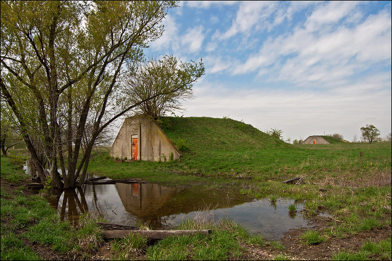
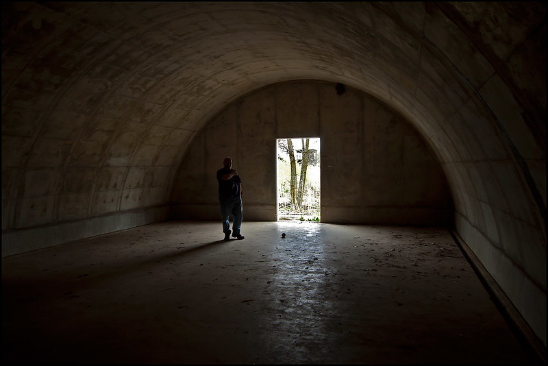
For now, a few of the bunkers are open for viewing. They are rather interesting to enter.  Only a single, heavy steel door leads in and out. No windows or emergency exits, the bunkers are dark, damp, and sounds inside have an unreal echo.

Inside the Bunker

Worth a trip just to view the WWII ammunition bunkers, but expect a long hike. Bring your hiking shoes, some water, and plenty of tick repellent!

Cicada Killer

Cicada Killer A cicada wasp drags home her large prey, which can take the better part of a day. Emerging in mid to late July, the cicada wasps relentlessly hunt the noisy cicada. Harmless to humans, the male cicada wasp cannot sting, and the female wasp is only interested in cicadas. You can find these wasps easily by their mounds of sand or soil. Mounds in lawns or gardens approximately 8 inches in diameter at this time of year are often signs of the burrows of the cicada wasp. The wasp digs these burrows, then hunts for a cicada. Once found, the wasp stings the cicada to paralyse it, then drags it to the burrow. Weighing twice as much as the wasp, this is often a difficult task, but eventually, the cicada is brought underground where it will lay alive for weeks. The wasp then lays an egg near the cicada - it will serve as food once the egg hatches. If you see a wasp measuring 1 1/2 to 2 inches in length flying around, don't worry - they're not interested in humans. They may fly around you to see what you are, but as long as you're not a cicada, there's nothing to worry about.

Heading Out

Heading Out The boys heading out into a flat calm Lake Michigan on a still summer morning. The weather has been pretty wet around the Midwest this year, and along with the moisture came plenty of storms. These storms really churned up the lake, creating high waves responsible for eroding the beaches along the Indiana shore. Here we were experiencing the calm between the storms, as more severe weather was predicted later in the day. It's hard to beleive they were walking into a lake that reaches 920 feet deep, and has some (if not THE) most powerful waves of all the world's fresh water lakes. Lake Michigan's length runs north and south, providing hundreds of miles of open water to build intense waves during storms.

Sculpted Dune

Sculpted Dune

The dunes along the Indiana shore of Lake Michigan take a pounding by the waves during windy days. In the last few years, this erosion seems to have accelerated; much of the flat beach is gone, and full sized trees that once stood on the dunes have been washed into Lake Michigan.

Once portions of the dune collapse, they are no longer covered in vegetation, and the sand is easily washed away by rain and wind.  Ever changing, the dunes are never the same twice, and on this early summer morning the patterns in the sand were striking.

Sand Sculptures

Looking like miniature versions of the buttes of the western United States, the complex patterns intrigued us as we hiked along the shore.

There's always something new and interesting to discover while hiking The Indiana Dunes National Lakeshore.

Sunset on the Farm

Sunset on the Farm

The end to a long day of hiking around rural Illinois was made perfect by this sunset near an old log cabin on the prairie. The light was no longer acceptable for images of the cabin, but the setting sun, windmill, and trees on the horizon yielded some great silhouettes.

Temperatures dropped dramatically right as the sun hit the horizon, and storms were on the way, but we managed to complete our photographic mission without encountering any rain.

Enjoying the Falls

Giant's Bathtub

Illinois' Matthiessen State Park packs plenty of scenery in its mile-long upper and lower dells trail. At least seven waterfalls wait for exploration in this narrow canyon covered by trees from the woods above.

The largest pool of water is the Devil's Bathtub, just below a cascade of two waterfalls. (pictured above)  A few meters beyond is Lake Falls, at around 35 feet tall.  To walk from one to the other, visitors must step in the stream at the top of the falls to Devil's Bathtub - the stream is only two or three inches deep at this point, and perhaps 5 feet wide, so not a large obstruction.

The trail running along the top of the dells is wooded, but doesn't offer too many views of the canyon below, however, there are a few points leading down to the dells if one prefers not to walk in the often muddy trails along the stream.

Less crowded than it's larger sister, Starved Rock State Park, Matthiessen offers quite a bit of interesting scenery not found in too many places in Illinois.

Severe Weather

Illuminated Clouds

While the storms never reached us, the distant lightning and overhead mammatus clouds kept us intrigued throughout the evening.  A cold front just south of our position, stalled, and produced some severe thunderstorms that just didnt' seem to move away.

Mammatus Clouds

Just before sunset, mammatus clouds appeared overhead, spun off from the thunderheads a few miles south. Almost constant thunder could be heard in the distance as we looked above at the unusual puffy, clouds.

Usually, mammatus clouds last for a few minutes, as the storm approaches, but on this evening, they stayed for at least two hours, perhaps longer as we could no longer see them after dark.

Lightning Bolt

The storm continued into the late evening. Around 10pm, constant flashes of distant lightning to the south kept us watching the horizon. Aside from the streaks of lightning, the illuminated clouds interested me even more.

Peaceful Sunset

Peaceful Sunset

The end to a beautiful spring day in rural America.

Hoping to arrive at our destination before the sun set below the horizon, I was a bit disappointed the sun was too low to illuminate the landscape.  The distant trees blocked the light, and the subjects that I intended to photograph during the "golden hour" were now in shadow.  Looking around a bit, I noticed the sun on the horizon, filtered by high, wispy clouds; providing the perfect back lighting for a great silhouette- especially next to the distant windmill.

Sometimes the landscape dictates what's going to happen, and when you listen, the outcome is usually better than the one you planned.